Geo Map - Asia - Singapore
Maps of Asia - Republic of Singapore
"Singapore, officially the Republic of Singapore, is a sovereign city-state and island country in Southeast Asia. It lies off the southern tip of the Malay Peninsula and is 137 kilometres (85 mi) north of the equator. Made up of the lozenge-shaped main island (widely known as Singapore Island but also as Pulau Ujong, its native Malay name) and over 60 much smaller islets, it is separated from Peninsular Malaysia by the Straits of Johor to its north and from Indonesia's Riau Islands by the Singapore Strait to its south. The country is highly urbanised, with very little primary rainforest remaining. Its territory has consistently expanded through land reclamation."
[Singapore. Wikipedia]
The vector stencils library Singapore contains contours for ConceptDraw DIAGRAM diagramming and vector drawing software. This library is contained in the Continent Maps solution from Maps area of ConceptDraw Solution Park.

Pic. 1. Continent Maps Solution
Use the Singapore library to draw thematic maps, geospatial infographics and vector illustrations for your business documents, presentations and websites.
Geo Map - Asia - Republic of Singapore
Singapore has a population of over 5,5 million and an area 719.1 km2(278 sq mi).

Pic. 2. Singapore
Geo Map - Asia - Singapore Contour
Capital - Singapore(city-state)

Pic. 3. Singapore Contour
Geo Map - Asia
Asia contains 48 countries(UN members) and 6 other states.
Area 44,579,000 km2 (17,212,000 sq mi). Population 4,164,252,000.

Pic. 4. Asia Map
Geo Map - Asia Contour
A contour map is a map illustrated with contour lines.

Pic. 5. Asia Contour
Geo Map - contours of Asia countries
Use the map contours library "Asia" to design thematic maps using the ConceptDraw DIAGRAM diagramming and vector drawing software.
The vector stencils library "Asia" contains 57 map contours: Asia political map, map contours of countries.

Pic. 6. Contours of Asia countries
All ConceptDraw DIAGRAM documents are vector graphic files and are available for reviewing, modifying, and converting to a variety of formats: image, HTML, PDF file, MS PowerPoint Presentation, Adobe Flash, MS Visio (.VDX, .VSDX).
See also Geo Maps of Asia Countries :
EIGHT RELATED HOW TO's:
outh Sudan, officially the Republic of South Sudan, is a landlocked country in northeastern Africa.
The vector stencils library South Sudan contains contours for ConceptDraw DIAGRAM diagramming and vector drawing software. This library is contained in the Continent Maps solution from Maps area of ConceptDraw Solution Park.
Picture: Geo Map - Africa - South Sudan
Related Solution:
Kansas is a U.S. state located in the Midwestern United States.
The vector stencils library Kansas contains contours for ConceptDraw DIAGRAM diagramming and vector drawing software. This library is contained in the Continent Maps solution from Maps area of ConceptDraw Solution Park.
Picture: Geo Map — USA — Kansas
Related Solution:
The vector stencils library Australia contains contours of New Zealand and Australian states and mainland territories for ConceptDraw DIAGRAM diagramming and vector drawing software.
Picture: Geo Map — Australia — New Zealand
Related Solution:
Delaware is a U.S. state located on the Atlantic Coast in the Northeastern and Mid-Atlantic regions of the United States.
The vector stencils library Delaware contains contours for ConceptDraw DIAGRAM diagramming and vector drawing software. This library is contained in the Continent Maps solution from Maps area of ConceptDraw Solution Park.
Picture: Geo Map — USA — Delaware
Related Solution:
Nova Scotia is one of Canada's three Maritime provinces and constitutes one of the four Atlantic Canada provinces.
The vector stencils library Nova Scotia contains contours for ConceptDraw DIAGRAM diagramming and vector drawing software. This library is contained in the Continent Maps solution from Maps area of ConceptDraw Solution Park.
Picture: Geo Map - Canada - Nova Scotia
Related Solution:
As restaurant industry is growing rapidly nowadays, researches show that almost half of the adults have worked in a restaurant or a cafe. Moreover, many of them dream to start their own someday. Unfortunately, it takes a lot of time to write a business plan and to find a great location, although some know how to create a restaurant floor plan in minutes or how to plan budget effortlessly. Hiring employees can also cause a lot of headache, but this is crucial for further success, because every guest comes to restaurant for a good service and delicious food. It is also worth noting that restaurant concept is also important, because it defines target audience and influences the menu.
This diagram represents the floor plan of an ongoing sports-theme establishment - restaurant, cafe, or other food service. A number of widescreen monitors installed along the perimeter provide visitors the opportunity to follow the course of a match from anywhere in the dining room of restaurant or cafe. The most of sports fans believe that food and alcohol is a big part of any sports show. That is why the dining room takes the most space - almost 60% of the total establishment space. Nearly all sports fans consume beverages while watching sports - beer, soda or water at least. Thus, the restaurant floor plan designers added a large lavatory there. Moreover, project developers considered unnecessary the gender division of such delicate place - perhaps they guess that only men are watching football, or believe that alcohol will eliminate the most of gender differences.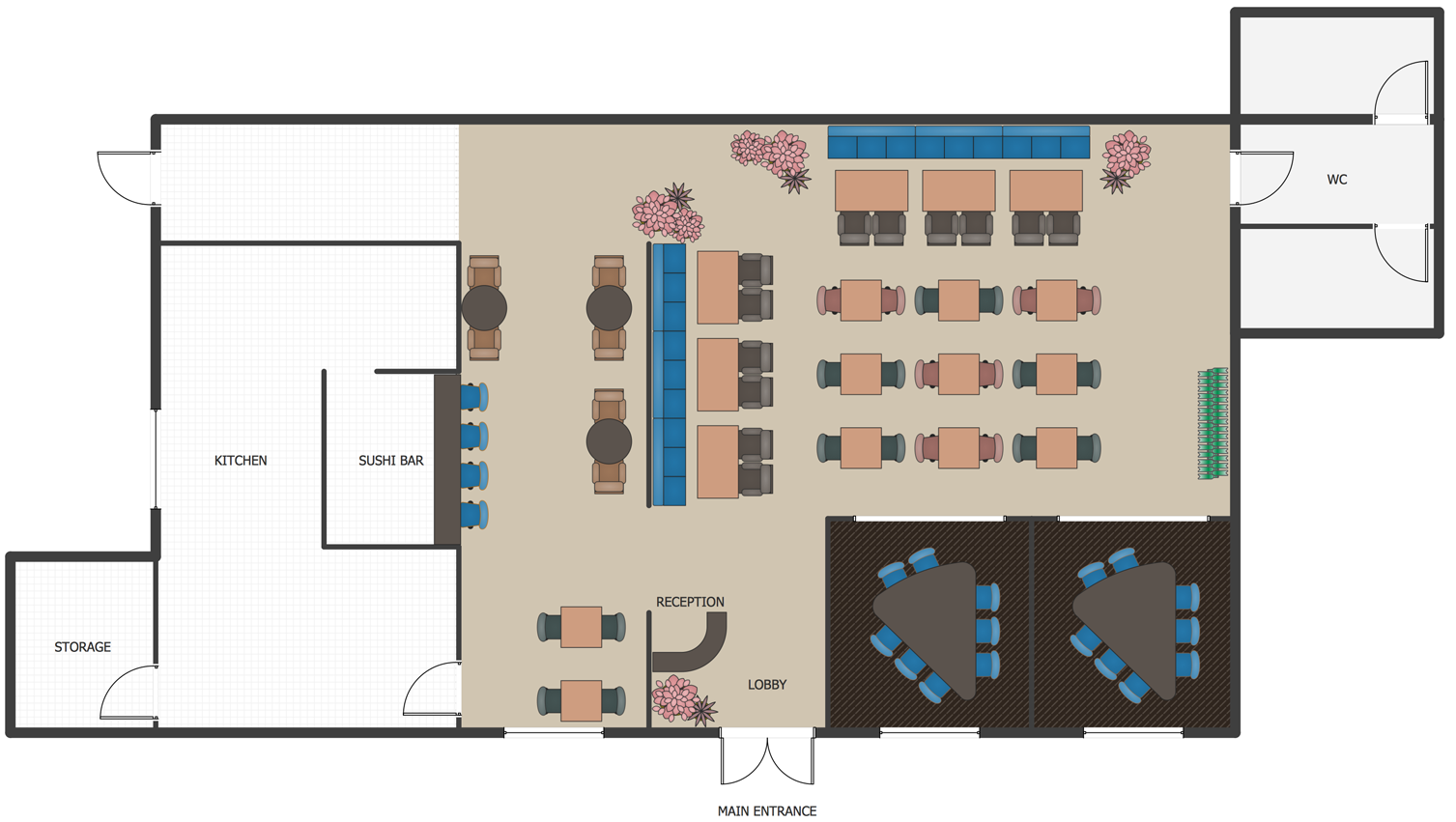
Picture: How To Create Restaurant Floor Plan in Minutes
Related Solution:
Bhutan, officially the Kingdom of Bhutan, is a landlocked country in South Asia located at the eastern end of the Himalayas.
The vector stencils library Bhutan contains contours for ConceptDraw DIAGRAM diagramming and vector drawing software. This library is contained in the Continent Maps solution from Maps area of ConceptDraw Solution Park.
Picture: Geo Map - Asia - Bhutan
Related Solution:
Turkmenistan, formerly also known as Turkmenia, is one of the Turkic states in Central Asia.
The vector stencils library Turkmenistan contains contours for ConceptDraw DIAGRAM diagramming and vector drawing software. This library is contained in the Continent Maps solution from Maps area of ConceptDraw Solution Park.
Picture: Geo Map - Asia - Turkmenistan
Related Solution:


