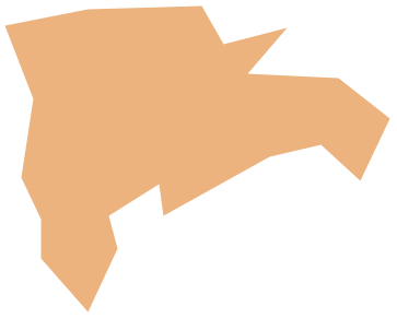
Geo Map — USA — Florida
Maps of USA — State of Florida
The name of the state Florida in the United States of America can be translated from Spanish to English as a "land of flowers". This state is located on the south-east coast of the United States and it is just next to the Gulf of Mexico, to Alabama state on the north as well as state Georgia. There is the Atlantic Ocean just on the east of the state and Cuba not far from America to the south from Florida. This state is on the third place of popularity and it is not a surprise: the weather conditions are relatively good, especially in summer, that is why people try to move to Florida, even though it is quite expensive to live there.
Florida is quite different from the other states taking into consideration its size and its high population growth. It is also popular for its increasing “environmental issues”. This state's economy relies on tourism as there are very many tourists visiting Florida all year long. It is a popular place for developing the agriculture business and so the logistic one as people grow quite many crops in Florida which can be delivered to the other states or even to the other countries. In general, transportation developed there in the late 19th century and also this state is famous for its amusement parks, which are very much liked by so many kids – both American and foreign.
The culture of Florida is mainly a simple reflection of influences and multiple inheritances of Native Americans, European Americans, Hispanics and Latinos, as well as African Americans heritages, which can be found both in the architecture and in the local cuisine. There were very many quite popular writers living in Florida, such as Ernest Hemingway, Tennessee Williams and Marjorie Kinnan Rawlings. This state continues to attract different celebrities and athletes, as well as more and more tourists each year. Florida is popular for people from all over the world to come and play golf, tennis, do different kinds of water sport as well as do auto racing.
Water sports are popular because Florida has its coastline prolonging for 2170 kilometres and the water is pretty much warm enough to do such sport most of the time during the year. Florida is the only state bordering both the Atlantic Ocean and the Gulf of Mexico. Most of the territory of the state is very close to the sea coasts or on the sea coast, but the weather in this state can vary during a year and its climate varies from subtropical in the north of Florida to the tropical in the south. There are many interesting animals in Florida, which can be found in the national parks, such as “Everglades National Park”. Visiting this park, you can see the alligator (“American alligator”), the crocodile, panther and other unique and rare animals.
Florida is on the west from the Bahamas which are the islands nearby and it is only 140 kilometres from Cuba to the north. This state is one of the largest ones where so many attractions are, such as the Mississippi River, which is truly large in its water area. The total water boundary of Florida is 5,6 kilometres offshore in the Atlantic Ocean and 17 kilometres offshore in the Gulf of Mexico. At the distance of 105 metres above the sea level the town named Britton Hill is the highest natural point in the state of Florida.
Florida was a challenge for the European colonial powers in 1513 before it gained statehood in the United States of America in 1845. Florida state was a principal location of the so-called “Seminole Wars” against the local people – the native Americans. As it was mentioned before, most of the territory of the state of Florida is on a peninsula between the Atlantic Ocean, the Gulf of Mexico and the “Straits of Florida”, which is also known as “Florida Straits” or “Florida Strait”. These Straits of Florida is simply as strait, which is located on the south-southeast of the North American land between the Atlantic Ocean and the Gulf of Mexico as well as between Cuba and the so-called “Florida Keys”. Florida Keys is an archipelago, located on the southern coast of the state of Florida, forming the southern portion of the continental territory of the United States of America. They can be found on the south-east of the coast of the Florida peninsula only about 24 kilometres to the south of Miami.
Florida state territory lies in two time zones extending to the north-western part of the state into a panhandle along the northern part of the Gulf of Mexico. The state is bordered on the north by the other states, which are Alabama and Georgia. Florida is the only state, which borders allow the access to both the Gulf of Mexico and the Atlantic Ocean. Most of the territory of the both Central and North Florida is at least 40 kilometres away from the coastline. In these cities and towns you can see the hills with elevations from 30 to 76 metres, but the highest pthe amountoint in Florida is the top of the mountain named “Sugarloaf Mountain”. Its peak is 95 metres above the sea level. In general, Florida is one of the flattest states in the United States of America.
There were over 20000000 people living in the Florida in 2015, but after that amount increased and now there should be at least 20271272 inhabitants. In 2010 the most popular place for people living in Florida was between Frostproof and Fort Meade. Nowadays it is 8 kilometres from that place more to the east and it is Polk Country. Florida contains the highest percentage of elderly people being over 65 years old and there are about 17% of them living in this state.
Knowing all of those facts, mentioned above, it is always possible to illustrate them in a way of a diagram, or simply draw a couple of maps, presenting the number of people, the size of the state as well as its neighbour states sizes. With ConceptDraw DIAGRAM software it is possible to make any needed map within only a couple of minutes having the “Continent Maps” solution, which can be found and downloaded from the “Maps” area of ConceptDraw Solution Park on this site or directly from ConceptDraw STORE application. The vector stencils library “Florida” from this solution contains the contours of the state for being used while working in ConceptDraw DIAGRAM diagramming and vector drawing software.
The vector stencils library Florida contains contours for ConceptDraw DIAGRAM diagramming and vector drawing software. This library is contained in the Continent Maps solution from Maps area of ConceptDraw Solution Park.
Pic. 1. Continent Maps Solution
Use the Florida library to draw thematic maps, geospatial infographics and vector illustrations for your business documents, presentations and websites.
Geo Map — USA — State of Florida
Area 65,755 sq mi (170,304 km2); Width 361 miles (582 km); Length 447 miles (721 km).
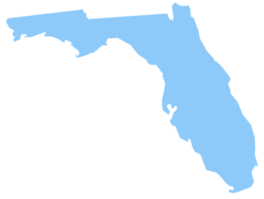
Pic. 2. State of Florida
Geo Map — USA — Florida Contour
Capital — Tallahassee.
Pic. 3. USA — Florida Contour
Geo Map — USA
The United States of America, is a federal republic composed of 50 states, a federal district, five major territories.
Pic. 4. USA Map
Geo Map — USA Contour
A contour map is a map illustrated with contour lines.
Pic. 5. USA Contour
Geo Map — Contours of Territories of the United States
Use the map contours library "United States of America" to design thematic maps using the ConceptDraw DIAGRAM diagramming and vector drawing software.
The vector stencils library "United States of America" contains 53 map contours: US political map, map contours of states.
Pic. 6. Contours of Territories of the United States
All ConceptDraw DIAGRAM documents are vector graphic files and are available for reviewing, modifying, and converting to a variety of formats: image, HTML, PDF file, MS PowerPoint Presentation, Adobe Flash, MS Visio (.VDX, .VSDX).
See Also Territories of the United States Geo Maps :
- Alabama
- Alaska
- Arizona
- Arkansas
- California
- Colorado
- Connecticut
- Delaware
- Florida
- Georgia
- Hawaii
- Idaho
- Illinois
- Indiana
- Iowa
- Kansas
- Kentucky
- Louisiana
- Maine
- Maryland
- Massachusetts
- Mexico
- Michigan
- Minnesota
- Mississippi
- Missouri
- Montana
- Nebraska
- Nevada
- New Hampshire
- New Jersey
- New Mexico
- New York
- North Carolina
- North Dakota
- Ohio
- Oklahoma
- Oregon
- Pennsylvania
- Tennesse
- Utah
- Vermont
- Virginia
- Washington
- West Virginia
- Wisconsin
- Wyoming
- United States
