 Directional Maps
Directional Maps solution extends ConceptDraw DIAGRAM software with templates, samples and libraries of vector stencils for drawing the directional, location, site, transit, road and route maps, plans and schemes.
"Road maps come in many shapes, sizes and scales. Small, single-page maps may be used to give an overview of a region's major routes and features. ...
Highway maps generally give an overview of major routes within a medium to large region ranging from a few dozen to a few thousand miles or kilometers.
Street maps usually cover an area of a few miles or kilometers (at most) within a single city or extended metropolitan area. City maps are generally a specialized form of street map." [Road map. Wikipedia]
This 3D pictorial road map example was created using the ConceptDraw PRO diagramming and vector drawing software extended with the Directional Maps solution from the Maps area of ConceptDraw Solution Park.
3D Directional map

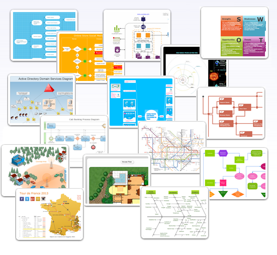
Examples of Flowcharts, Org Charts and More
 Maps
Maps
This solution extends ConceptDraw DIAGRAM.4 with the specific tools necessary to help you draw continental, directional, road, or transit maps, to represent international, business, or professional information visually.
The 3D pictorial street maps are used as road maps, route maps, locator maps, transit maps, directional maps, tourist maps with points of interest (POI).
"A point of interest, or POI, is a specific point location that someone may find useful or interesting. ...
Most consumers use the term when referring to hotels, campsites, fuel stations or any other categories used in modern (automotive) navigation systems. ...
The term is widely used in cartography, especially in electronic variants including GIS, and GPS navigation software. In this context the synonym waypoint is common.
A GPS point of interest specifies, at minimum, the latitude and longitude of the POI, assuming a certain map datum. A name or description for the POI is usually included, and other information such as altitude or a telephone number may also be attached. GPS applications typically use icons to represent different categories of POI on a map graphically." [Point of interest. Wikipedia]
The example "3D pictorial street map" was created using the ConceptDraw PRO diagramming and vector drawing software extended with the Directional Maps solution from the Maps area of ConceptDraw Solution Park.
3D pictorial street map

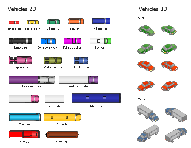
The vector stencils library "Vehicles (2D)" contains 21 icons. The library "Vehicles (3D)" contains 12 icons.
Use these icons for creating the pictorial road and rout maps, directional and locator maps, transit and street maps, road traffic and automotive transport moving diagrams using the ConceptDraw PRO diagramming and vector drawing software.
The example "Design elements - Vehicles 2D, 3D" is included in the Directional Maps solution from the Maps area of ConceptDraw Solution Park.
Vehicle symbols
 Pyramid Diagrams
Pyramid Diagrams solution extends ConceptDraw DIAGRAM software with templates, samples and library of vector stencils for drawing the marketing pyramid diagrams.
 Block Diagrams
Block diagrams solution extends ConceptDraw DIAGRAM software with templates, samples and libraries of vector stencils for drawing the block diagrams.
 Audio, Video, Media
Use it to make professional-looking documents, impressive presentations, and efficient websites with colorful and vivid illustrations and schematics of digital audio, video and photo gadgets and devices, audio video connections and configurations, S Video connection, HD and 3D television systems, home entertainment systems, Closed-circuit television (CCTV) surveillance systems. All audio video schematics, drawings and illustrations designed in ConceptDraw DIAGRAM are professional looking, clear and understandable for all thanks to applying the most commonly used standards of designations, and are effective for demonstrating in front of a small audience and on the big screens.
Point-to-multipoint (P2MP) Network. Computer and Network Examples
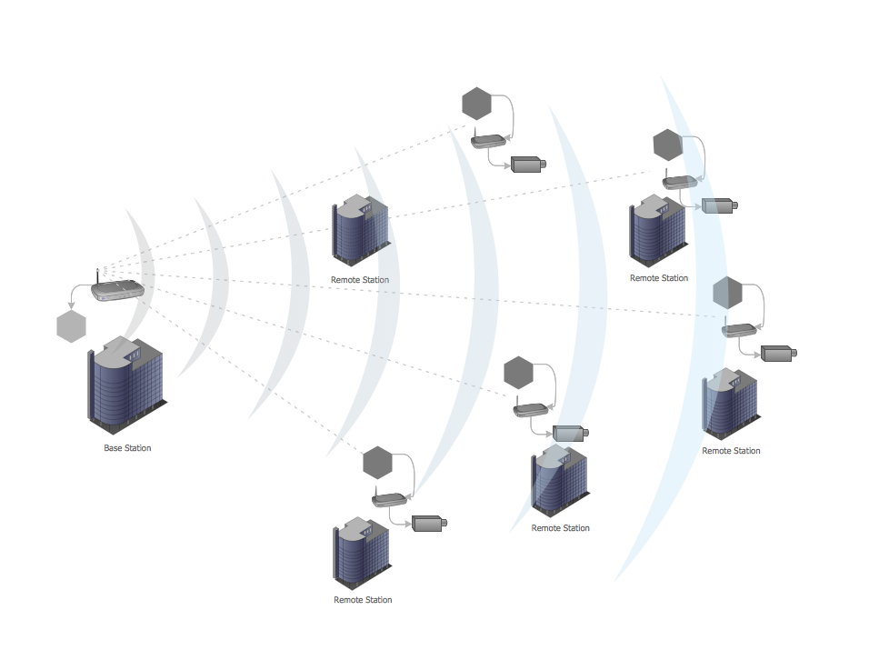

 Illustration Area
Solutions from the Illustrations Area of ConceptDraw Solution Park collect templates, samples and libraries of color scalable vector stencils, icons and clip art for illustrating documents, presentations, infographics, web sites and blogs.
- Directional Maps | 3D directional map example | Neighborhood 3D ...
- 3D directional map example | Directional map for the hotel ...
- 3D Network Diagram Software | Pyramid Diagram | Neighborhood ...
- 3D directional maps
- Maps | 2D Directional map template | 3D Directional map template
- Directional Maps | 3D pictorial road map | Examples of Flowcharts ...
- 3D pictorial road map | 3D Directional map template | 2D Directional ...
- 3D Directional map template | 3D pictorial street map | Network ...
- 3D pictorial road map | 3D Directional map template | Design ...
- Examples of Flowcharts, Org Charts and More | 3D pictorial road ...
- Design elements - 3D directional maps | Design elements - Subway ...
- 3D Network Diagram Software | Maps | Design elements - 3D ...
- Road Transport - Design Elements | 3D Directional map template ...
- 3D pictorial street map | Directional Maps | Map Of A Neighborhood
- 3D Network Diagram Software
- 3D pictorial street map | Directional Maps | Design elements ...
- Maps | Design elements - 3D directional maps | 3D pictorial road ...
- Design elements - 3D directional maps | Design elements - Subway ...
- Design elements - 3D directional maps | Maps Area | Metro Map ...
- 3D pictorial street map | Design elements - 3D directional maps | 3D ...