Geo Map - Asia - Papua New Guinea

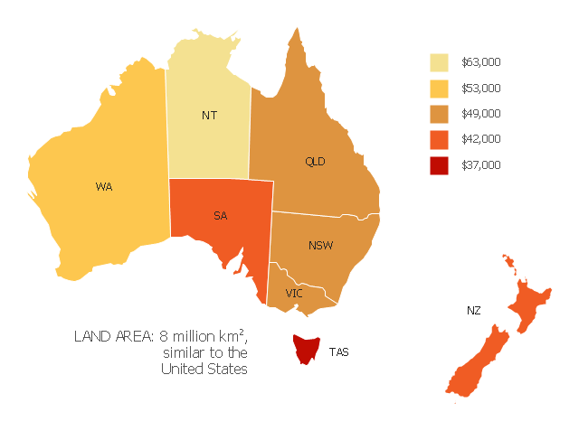
"Household income is a measure of the combined incomes of all people sharing a particular household or place of residence. It includes every form of income, e.g., salaries and wages, retirement income, near cash government transfers like food stamps, and investment gains.
Average household income can be used as an indicator for the monetary well-being of a country's citizens. Mean or median net household income, after taxes and mandatory contributions, are good indicators of standard of living, because they include only disposable income and acknowledge people sharing accommodation benefit from pooling at least some of their living costs.
Average household incomes need not map directly to measures of an individual's earnings such as per capita income as numbers of people sharing households and numbers of income earners per household can vary significantly between regions and over time." [Household income. Wikipedia]
This map example shows 2007 median household incomes in the states and mainland territories of the Commonwealth of Australia.
The thematic map example "Map of median household income in Australia" was redesigned from the Wikimedia Commons file: Map of median household income in Australia.PNG.
[commons.wikimedia.org/ wiki/ File:Map_ of_ median_ household_ income_ in_ Australia.PNG]
The example "Map of median household income in Australia" was created using the ConceptDraw PRO diagramming and vector drawing software extended with the Continent Map solution from the Maps area of ConceptDraw Solution Park.
Thematic map - Australia
Geo Map - Australia

Geo Map - Europe - Bulgaria

Geo Map - Australia - Nothern Territory

Geo Map - Australia - South Australia

Geo Map - Australia - Tasmania

Australia Map

The vector stencils library "Asia" contains 57 Asian state map contours for drawing thematic and political maps of Asia. Use it for visual representation of geospatial information, statistics and quantitative data.
"Asia is the Earth's largest and most populous continent, located primarily in the eastern and northern hemispheres. ... Countries: 49 (and 5 disputed)." [Asia. Wikipedia]
The state map contours example "Asia - Vector stencils library" was created using the ConceptDraw PRO diagramming and vector drawing software extended with the Continent Maps solution from the Maps area of ConceptDraw Solution Park.
Asia

Central Asia

South Asia

East Asia

Southeast Asia

Afghanistan

Armenia

Azerbaijan

Bahrain

Bangladesh

Bhutan

Brunei

Burma (Myanmar)
-asia---vector-stencils-library.png--diagram-flowchart-example.png)
Cambodia

China

Cyprus

Georgia

India

Indonesia

Iran

Iraq

Israel

Japan

Jordan

Kazakhstan

Kuwait

Kyrgyzstan

Laos

Lebanon

Malaysia

Maldives

Mongolia

Nepal

North Korea

Oman

Pakistan

Papua New Guinea

Philippines

Qatar

Russia (Asia)
-asia---vector-stencils-library.png--diagram-flowchart-example.png)
Saudi Arabia

Singapore

South Korea

Sri Lanka

Syria

Taiwan

Tajikistan

Thailand

Turkey

Turkmenistan

United Arab Emirates

Uzbekistan

Vietnam

Yemen

Aral Sea

Caspian Sea

Lake Balkhash

Geo Map - Australia - New South Wales

Geo Map - Australia - Victoria

Geo Map - Europe

Geo Map - Australia - New Zealand

Geo Map - Australia - Western Australia

 Australia Map
For graphic artists creating accurate maps of Australia. The Australia Map solution - allows designers to map Australia for their needs, offers a collection of scalable graphics representing the political geography of Australia, split into distinct state
- Map of median household income in Australia | How To Do A Mind ...
- Map of Germany — Lower Saxony State | Geo Map - Europe ...
- Geo Map - Australia | Geo Map - Asia - Papua New Guinea | Geo ...
- Geo Map - Asia - Papua New Guinea | Geo Map - Europe - Bulgaria ...
- Geo Map - Asia - Papua New Guinea | Geo Map - Europe - Bulgaria ...
- Geo Map - Asia - Papua New Guinea | South Asia - Political map ...
- India Map Png
- Map Of India Png
- Geo Map - Asia - Papua New Guinea | Political map of Central ...
- Aisa Map Png
- Map of median household income in Australia | Continent Maps ...
- India Map Png File
- Geo Map - Australia - South Australia | Geo Map - Africa - South ...
- New Zealand Map Outline Png
- Continental Map Png
- South Asia - Political map | Geo Map - Asia - Papua New Guinea ...
- Indian Map Png
- Geo Map - South America - Chile | 7 Continents Map | Geo Map ...
- Geo Map - Canada - Prince Edward Island | Geo Map - Australia ...
- South America - Political map | Andean states - Political map | South ...