"Emergency evacuation is the immediate and urgent movement of people away from the threat or actual occurrence of a hazard. Examples range from the small scale evacuation of a building due to a storm or fire to the large scale evacuation of a district because of a flood, bombardment or approaching weather system. In situations involving hazardous materials or possible contamination, evacuees may be decontaminated prior to being transported out of the contaminated area. ...
Planning.
Emergency evacuation plans are developed to ensure the safest and most efficient evacuation time of all expected residents of a structure, city, or region. A benchmark "evacuation time" for different hazards and conditions is established. These benchmarks can be established through using best practices, regulations, or using simulations, such as modeling the flow of people in a building, to determine the benchmark. Proper planning will use multiple exits, contra-flow lanes, and special technologies to ensure full, fast and complete evacuation. Consideration for personal situations which may affect an individual's ability to evacuate is taken into account, including alarm signals that use both aural and visual alerts, and also evacuation equipment such as sleds, pads, and chairs for non-ambulatory people. Regulations such as building codes can be used to reduce the possibility of panic by allowing individuals to process the need to self-evacuate without causing alarm. Proper planning will implement an all-hazards approach so that plans can be reused for multiple hazards that could exist." [Emergency evacuation. Wikipedia]
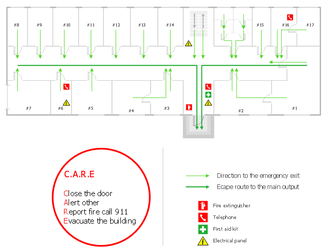
The evacuation plan example was created using the ConceptDraw PRO diagramming and vector drawing software extended with the Fire and Emergency Plans solution from the Building Plans area of ConceptDraw Solution Park.
www.conceptdraw.com/ solution-park/ building-fire-emergency-plans
Planning.
Emergency evacuation plans are developed to ensure the safest and most efficient evacuation time of all expected residents of a structure, city, or region. A benchmark "evacuation time" for different hazards and conditions is established. These benchmarks can be established through using best practices, regulations, or using simulations, such as modeling the flow of people in a building, to determine the benchmark. Proper planning will use multiple exits, contra-flow lanes, and special technologies to ensure full, fast and complete evacuation. Consideration for personal situations which may affect an individual's ability to evacuate is taken into account, including alarm signals that use both aural and visual alerts, and also evacuation equipment such as sleds, pads, and chairs for non-ambulatory people. Regulations such as building codes can be used to reduce the possibility of panic by allowing individuals to process the need to self-evacuate without causing alarm. Proper planning will implement an all-hazards approach so that plans can be reused for multiple hazards that could exist." [Emergency evacuation. Wikipedia]
The evacuation plan example was created using the ConceptDraw PRO diagramming and vector drawing software extended with the Fire and Emergency Plans solution from the Building Plans area of ConceptDraw Solution Park.
www.conceptdraw.com/ solution-park/ building-fire-emergency-plans
Evacuation plan
Map of Germany

EIGRP. Computer and Network Examples

EIGRP is used to help automate routing decisions and configuration of the computer network. It allows the routers of the same logical area automatically share route information.

- Evacuation plan | Fire Evacuation Plan Template | Emergency Plan ...
- Evacuation plan | Fire Exits Building Regulations
- Evacuation plan | Aerospace and Transport | Layout Of A Small First ...
- Emergency Plan | Fire Evacuation Plan Template | Fire and ...
- Evacuation plan | Aerospace and Transport | Landscape ...
- Drawing Evacuation Plans
- Evacuation plan | Exit Door Regulations
- Emergency Plan | Fire Exit Plan . Building Plan Examples | How To ...
- Evacuation plan | Value stream map parts | Plan Vs Actual P
- Fire Exit Plan . Building Plan Examples | Evacuation plan | Design ...
- Evacuation plan | Structural Drawing Of A Small First Aid Room
- Fire and Emergency Plans | Interior Design Machines and ...
- How To Create Restaurant Floor Plan in Minutes | Office Layout ...
- Evacuation Plan For Hospitals
- Evacuation plan | Exits Required By Building Code
- Evacuation plan | Aerospace and Transport | The Requirements And ...
- Evacuation Plan Software
- Fire Evacuation Plan Template | How to draw Metro Map style ...
- Evacuation plan | Fire Exits Regulations
- Security and Access Plans | Security Plans | Physical Security Plan ...