 Continent Maps
Continent Maps solution extends ConceptDraw DIAGRAM software with templates, samples and libraries of vector stencils for drawing the thematic maps of continents, state maps of USA and Australia.
Map of Continents

 Australia Map
For graphic artists creating accurate maps of Australia. The Australia Map solution - allows designers to map Australia for their needs, offers a collection of scalable graphics representing the political geography of Australia, split into distinct state
Map Software

Geo Map - Europe - Czech Republic
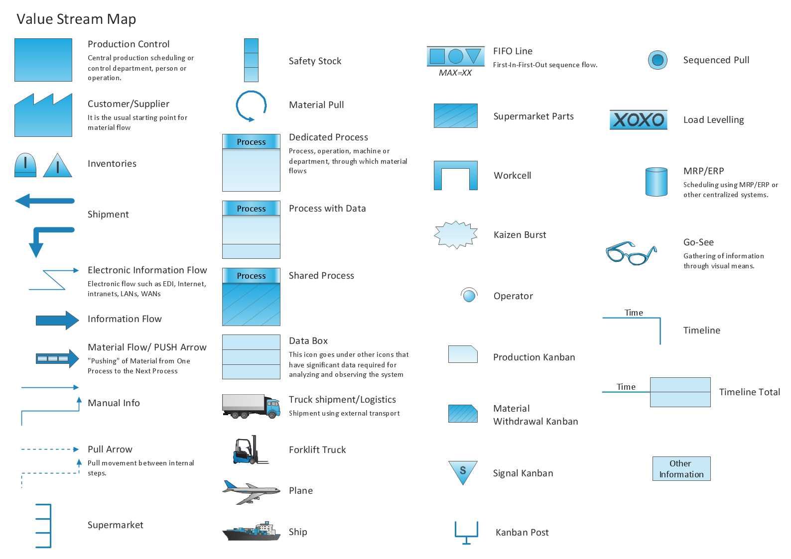
Learn how to create a current state value stream map
 Germany Map
The Germany Map solution contains collection of samples, templates and scalable vector stencil graphic maps, representing map of Germany and all 16 states of Germany. Use the Germany Map solution from ConceptDraw Solution Park as the base for various them
Geo Map — South America Continent

ConceptDraw DIAGRAM is idea to draw the geological maps of South America continent from the pre-designed vector geo map shapes.
Use Continent Maps solution from the Maps area of ConceptDraw Solution Park to draw thematic maps, geospatial infographics and vector illustrations for your business documents, presentations and websites.
7 Continents Map

World Continents Map

- Directional Maps | How to Create a Directional Map Using ...
- The 100th Tour de France - Route map | How to Create a Powerful ...
- Continent Maps | Sample Of Political Map Of Europe
- Learn how to create a current state value stream map | Map of USA ...
- 2D Directional map - Template
- How to Create a Map Depicting the United Kingdom Counties and ...
- USA Maps | How to Create a Map of Germany Using ConceptDraw ...
- Europe Political Map
- Political map of Europe | European membership of the EU and ...
- Political map of Europe | Geo Map - Europe - United Kingdom | Map ...
- ERD | Entity Relationship Diagrams, ERD Software for Mac and Win
- Flowchart | Basic Flowchart Symbols and Meaning
- Flowchart | Flowchart Design - Symbols, Shapes, Stencils and Icons
- Flowchart | Flow Chart Symbols
- Electrical | Electrical Drawing - Wiring and Circuits Schematics
- Flowchart | Common Flowchart Symbols
- Flowchart | Common Flowchart Symbols