HelpDesk
How to Draw a Map of North America
Geographic maps, cardiograms, and thematic maps are often used for geographical visualization of business information. Any country can inspire a wealth of geopolitical statistical data. A common way of assimilating this data is to create maps that convey a particular theme or subject matter in relation to a specific geographical area. Known as thematic maps, they cover themes such as population density, average rainfall, or political allegiance, differentiating the data by using graphical elements and annotation. Thematic maps contrast general reference maps, which tend to display information on a variety of subjects — vegetation, topology, roads, and highways, for example. A thematic map will always focus on one particular subject matter. ConceptDraw DIAGRAM can be helpful as a tool for creating maps of countries and regions of the world. It allows you to draw continental maps quickly and easily using the special templates and vector stencils libraries.HelpDesk
How to Create a Map of Germany
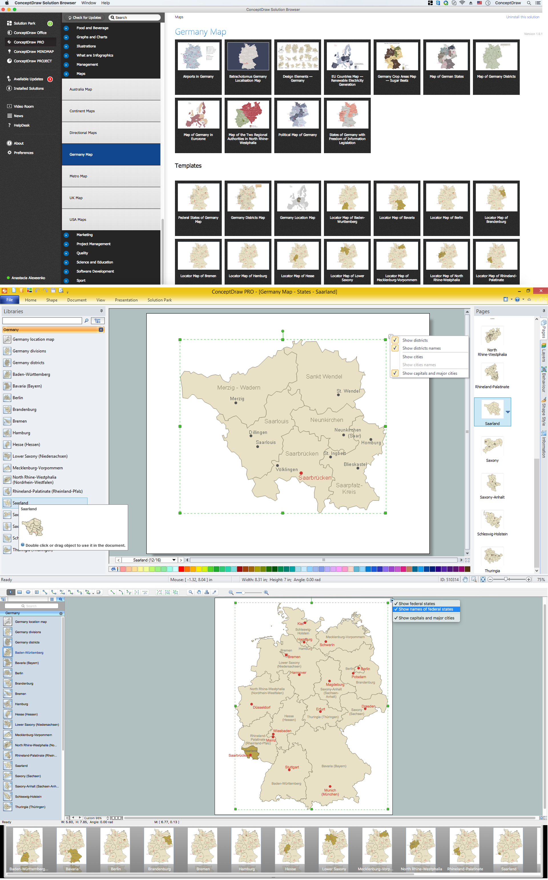
Geographical thematic maps are used to display information on a variety of subjects. It is a common way of representing any form of spatial data in relation to a specific geographical area. The Germany Map Solution for ConceptDraw DIAGRAM includes all of the German federal states with county outlined borders and major cities. You can quickly create geographic maps, cartograms, and thematic maps for geographical visualization information for business and travels.HelpDesk
How to Create a Map Depicting the United Kingdom Counties and Regions
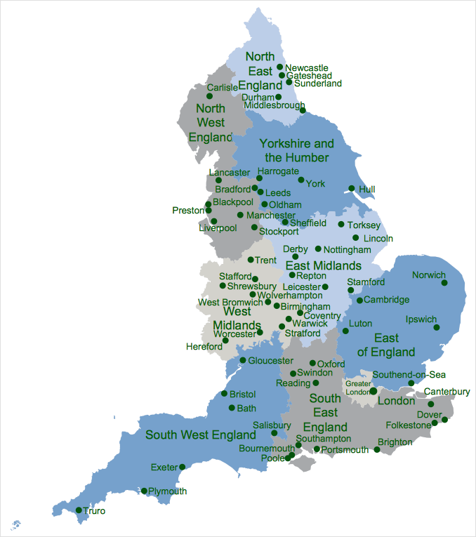
The UK Map Solution for ConceptDraw DIAGRAM includes all of the UK counties with county outlined borders, from the largest, North Yorkshire, to the smallest Rutlandshire. Geographical thematic maps are used to visualize information on a number of subjects related to certain geographical location. It is a common way of representing any form of spatial data in relation to a specific geographical area. The UK Map Solution for ConceptDraw DIAGRAM includes all of the United Kingdom counties with county outlined borders and major cities. You can quickly create geographic maps, cartograms, and thematic maps for geographical visualization information for business and travels.HelpDesk
How to Draw Maps of Australia
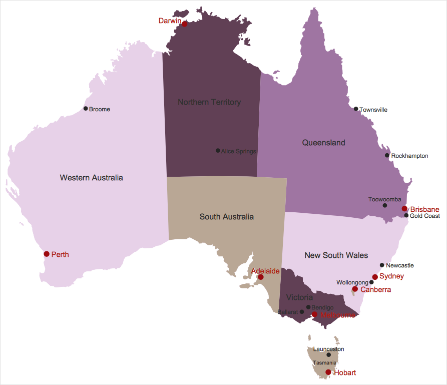
Australia is the sixth largest country in the world. Australia consists from the mainland which is surrounded by many thousands of small fringing islands and numerous larger ones. The vast territories, aligned with interesting historic features across a wide expanse, make the thematic map an ideal way of depicting geographical, geological and political information related to Australia. The Australia Map solution for ConceptDraw DIAGRAM will help you to make the steps of the creativeness easy and intuitive. The Australia Map solution provides templates and samples along with vector stencils to get you started. Used together with other ConceptDraw DIAGRAM solutions it will allow you to create comprehensive geography-related infographics.HelpDesk
How to Create a Directional Map
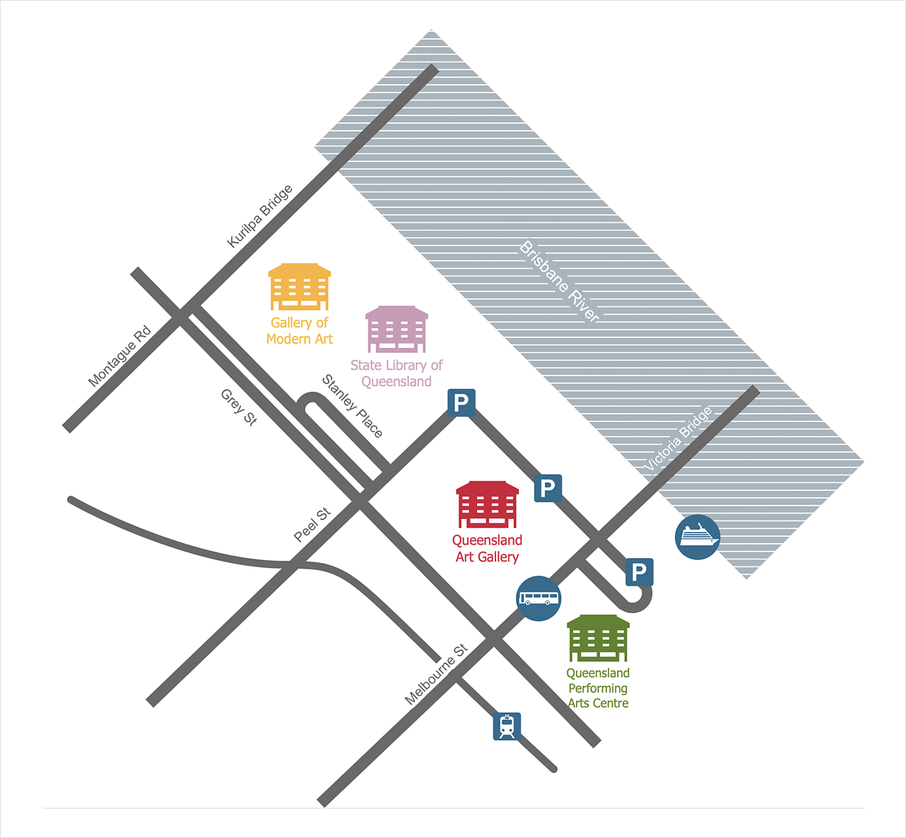
Travelers often use directional maps to find directions for certain places. These maps are guiding millions of tourists to explore towns and cities worldwide. Searching addresses on a map, view nearby businesses, get driving directions - this is only a little of what directional maps is needed. ConceptDraw DIAGRAM allows you to create various kinds of directional maps. You can easily visualize city maps or destinations with driving directions and traveler information using special vector stencils libraries.Map of Germany — Saarland State
The Saarland is one of the sixteen federal states (or Bundesländer) of Germany. The capital city is Saarbrücken. Despite the fact that the maps surround us everywhere in our life, usually the process of their drawing is sufficienly complex and labor-intensive. But now, thanks to the ConceptDraw DIAGRAM diagramming and vector drawing software extended with Germany Map Solution from the Maps Area of ConceptDraw Solution Park, we have the possibility to make easier this process. Design fast and easy your own pictorial maps of Germany, map of Germany with cities, and thematic Germany maps in ConceptDraw DIAGRAM !Geo Map — Europe — Greece
Greece is strategically located at the crossroads of Europe, Asia, and Africa. The vector stencils library Greece contains contours for ConceptDraw DIAGRAM diagramming and vector drawing software. This library is contained in the Continent Maps solution from Maps area of ConceptDraw Solution Park.Examples of Flowcharts, Org Charts and More
ConceptDraw DIAGRAM covers a broad spectrum of business graphics categories and offers at ConceptDraw STORE enormous online collection of pictorial examples and samples for different thematics and application areas. It is a plentiful source of inspiration and wonderful examples of professionally designed diagrams, flowcharts, UML diagrams, organizational charts, databases, ERDs, network diagrams, business charts, different thematic charts, schematics, infographics and plans developed specially for knowledge workers, engineers, managers, businessmen, marketing specialists, analytics, scientists, students, professors, journalists and also for a large number of other people that every day use various diagrams and drawings in their work and life activity. Each of these examples is a real art, all they are well thought-out and designed without efforts with help of powerful tools of ConceptDraw DIAGRAM software. ConceptDraw examples display all variety of tasks, possibilities and results that ConceptDraw Product Line lets achieve fast and easy. ConceptDraw is one of the best Visio alternatives for Mac. It open all Visio formats like.vsdx,.vss,.vdx files and allows you to export files to Visio formats.
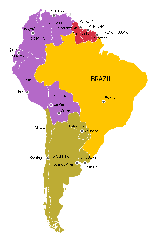
"The Andean States are a group of nations in South America that are defined by sharing a common geography (Andes mountain range) or culture such as the Quechua language and Andean cuisine which was primarily spread during the times of the Inca Empire, but also before and after it.
Politically speaking, Argentina and Chile are usually not considered part of the Andean States as they lack a strong native Andean heritage and are culturally more oriented towards Europe and they are not a members of the Andean Community of Nations (which Venezuela is in the process of leaving).
The Andes occupy the western part of South America, stretching through the following countries: Colombia, Venezuela, Ecuador, Peru, Bolivia, Argentina (not considered to be -geopolitically- an Andean State), Chile (not considered to be -geopolitically- an Andean State)." [Andean states. Wikipedia]
"Southern Cone (Spanish: Cono Sur, Portuguese: Cone Sul) is a geographic region composed of the southernmost areas of South America, south of and around the Tropic of Capricorn. Traditionally, it covers Argentina, Chile and Uruguay, bounded on the west by the Pacific Ocean, and south to the junction between the Pacific and Atlantic Oceans, which is the closest continental area of Antarctica (1000 km). In terms of social and political geography, the Southern Cone comprises Argentina, Chile, Paraguay, Uruguay, Southern Brazil and the Brazilian state of São Paulo.
High life expectancy, the highest Human Development Index of Latin America, high standard of living, significant participation in the global markets and the emerging economy of its members make the Southern Cone the most prosperous macro-region in South America." [Southern Cone. Wikipedia]
Eastern South America (Brazil). "Brazil Listeni/ brəˈzɪl/ (Portuguese: Brasil, IPA: [bɾaˈziw]), officially the Federative Republic of Brazil (Portuguese: República Federativa do Brasil, About this sound listen (help·info)), is the largest country in both South America and the Latin American region. It is the world's fifth largest country, both by geographical area and by population. It is the largest Portuguese-speaking country in the world, and the only one in the Americas. Bounded by the Atlantic Ocean on the east, Brazil has a coastline of 7,491 km (4,655 mi). It is bordered on the north by Venezuela, Guyana, Suriname and the French overseas region of French Guiana; on the northwest by Colombia; on the west by Bolivia and Peru; on the southwest by Argentina and Paraguay and on the south by Uruguay. Numerous archipelagos form part of Brazilian territory, such as Fernando de Noronha, Rocas Atoll, Saint Peter and Paul Rocks, and Trindade and Martim Vaz. It borders all other South American countries except Ecuador and Chile and occupies 47 percent of the continent of South America." [Brazil. Wikipedia]
"The Guianas, sometimes called by the Spanish loan-word Guayanas (Las Guayanas) refers to a region in north-eastern South America which includes the following three territories:
(1) French Guiana, an overseas department of France,
(2) Guyana, known as British Guiana from 1831 until 1966, after the colonies of Berbice, Essequibo, and Demerara, taken from the Netherlands in 1814, were merged into a single colony,
(3) Suriname, until 1814 a part of Dutch Guiana, together with Berbice, Essequibo and Demerara." [The Guianas. Wikipedia]
This political map sample was redesigned from the Wikimedia Commons file: South America Color-coded Regions.png. [commons.wikimedia.org/ wiki/ File:South_ America_ Color-coded_ Regions.png]
This file is licensed under the Creative Commons Attribution-Share Alike 3.0 Unported license. [creativecommons.org/ licenses/ by-sa/ 3.0/ deed.en]
The example "South America regions - Political map" was created using the ConceptDraw PRO diagramming and vector drawing software extended with the Continent Maps solution from the Maps area of ConceptDraw Solution Park.
Communication Tool for Remote Project Management
Communication is the main challenge and the key success factor for remote project management. Communicating visually via Skype you bring all team and customers onto the one page. Remote Presentation for Skype solution for ConceptDraw MINDMAP helps communicate with remote team and customers in visual manner on wide range of issues. Using this solution for regular status meetings allows you to push your team on tasks and keep task statuses up to date.- Illustration | Universal Diagramming Area | Schedule pie chart ...
- Drawing Of Geographical Range
- Schedule pie chart - Daily action plan | Composition Dashboard ...
- Schedule pie chart - Daily action plan | Project Management Area ...
- Schedule pie chart - Daily action plan | Target and Circular ...
- Schedule pie chart - Daily action plan | Flow Chart Symbols | Target ...
- Schedule pie chart - Daily action plan | PM Planning | Project ...
- Design elements - Geography | Geography - Vector stencils library ...
- Transport Map Template
- How To Draw Building Plans | Fire Exit Plan. Building Plan ...
- Maps | Map of Continents | South America regions - Political map ...
- Transit map template
- Geo Map - United States of America Map | How to Draw Maps of ...
- Drawing Europe Map
- Transit map template | Maps | Design elements - Transport map ...
- Transit map template
- World Continents Map | Continent Maps | South America regions ...
- How to Draw a Block Diagram in ConceptDraw PRO | How to Create ...
- How To Draw Building Plans | Check Order Process Flowchart ...
- Continents and Oceans Map | Geo Map - Asia - Mongolia | Continent ...


