 Metro Map
Metro Map solution extends ConceptDraw PRO software with templates, samples and library of vector stencils for drawing the metro maps, route maps, bus and other transport schemes, or design tube-style infographics.
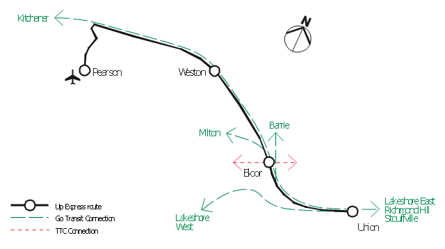
"An airport rail link is a service providing passenger rail transport from an airport to a nearby city; by mainline- or commuter trains, rapid transit, people mover or light rail. Direct links operate straight to the airport terminal, while other systems require an intermediate use of people mover or shuttle bus.
Although airport rail links have been popular solutions in Europe and Japan for decades, only recently have links been constructed in North America and Oceania, and the rest of Asia. Advantages for the rider include faster travel time and easy interconnection with other public transport, while authorities have benefited from less highway and parking congestion, less pollution, and additional business opportunities. Additionally, the links benefit airports by drawing in more passengers via easy access." [Airport rail link. Wikipedia]
This route map example was redesigned from the Wikimedia Commons file: ARL route map.png. [commons.wikimedia.org/ wiki/ File:ARL_ route_ map.png]
This file is made available under the Creative Commons CC0 1.0 Universal Public Domain Dedication. [creativecommons.org/ publicdomain/ zero/ 1.0/ deed.en]
The example "ARL route map" was created using the ConceptDraw PRO diagramming and vector drawing software extended with the Metro Map solution from the Maps area of ConceptDraw Solution Park.
Route map
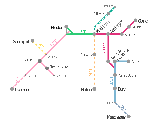
This is example of route map for the former East Lancashire Railway, in Lancashire, England.
It was redesigned from the Wikimedia Commons file: ELR route map.png. [commons.wikimedia.org/ wiki/ File:ELR_ route_ map.png]
This file is licensed under the Creative Commons Attribution-Share Alike 3.0 Unported license. [creativecommons.org/ licenses/ by-sa/ 3.0/ deed.en]
The example "ELR route map" was created using the ConceptDraw PRO diagramming and vector drawing software extended with the Metro Map solution from the Maps area of ConceptDraw Solution Park.
Route map
 Metro Map
Metro Map solution extends ConceptDraw PRO software with templates, samples and library of vector stencils for drawing the metro maps, route maps, bus and other transport schemes, or design tube-style infographics.
- Superb Examples of Infographic Maps | The 100th Tour de France ...
- ARL route map
- Fire Exit Plan. Building Plan Examples | How to draw Metro Map ...
- Evacuation Route Map Sample
- ELR route map | ARL route map | Emergency Plan | Route Map Png
- ARL route map | Germany Map | Fire Exit Plan. Building Plan ...
- Metro Maps | Subway Train Map | Metro Map | Route Map Easy ...
- Emergency Escape Route Map
- 3D pictorial road map | ARL route map | Rolla USGS Center locator ...
- ELR route map | Subway Train Map | Metro Map | Elr Maps
- Directional Maps | How to Create a Directional Map Using ...
- Brilliant Examples of Infographics Map , Transport, Road | Spatial ...
- Holiday | ELR route map | How to Draw a Pyramid Diagram in ...
- The 100th Tour de France - Route map | How To use House ...
- ELR route map | Telecommunication Network Diagrams ...
- The 100th Tour de France - Route map | Aircraft - Vector stencils ...
- Route Map Diagram
- Metro Map | Computer and Networks Area | Draw Airline Route Map
- Directional Maps | Map Directions | Directions Map | Example Of ...
- Map Directions | How to draw Metro Map style infographics? (New ...