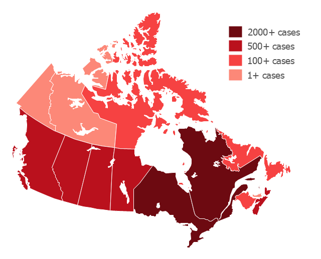
"The 2009 flu pandemic in Canada is part of an epidemic in 2009 of a new strain of influenza A virus subtype H1N1 causing what has been commonly called swine flu. In Canada, roughly 10% of the populace (or 3.5 million) has been infected with the virus, with 428 confirmed deaths (as of 20 February 2010); non-fatal individual cases are for the most part no longer being recorded. About 40% of Canadians have been immunized against H1N1 since a national vaccination campaign began in October, with Canada among the countries in the world leading in the percentage of the population that has been vaccinated." [2009 flu pandemic in Canada. Wikipedia]
This Canada thematic map example was redesigned using ConceptDraw PRO diagramming and vector drwing software from the Wikipedia file: H1N1 Canada Map by confirmed cases.svg.
[en.wikipedia.org/ wiki/ File:H1N1_ Canada_ Map_ by_ confirmed_ cases.svg]
This file is licensed under the Creative Commons Attribution-Share Alike 3.0 Unported license.
[creativecommons.org/ licenses/ by-sa/ 3.0/ deed.en]
This Canada thematic map example was created using ConceptDraw PRO diagramming and vector drawing software extended with Continent Maps solution from Maps area of ConceptDraw Solution Park.
 Continent Maps
Continent Maps solution extends ConceptDraw PRO software with templates, samples and libraries of vector stencils for drawing the thematic maps of continents, state maps of USA and Australia.
Maps — Continent Maps
- Canada political map | Canada regions map | 2009 flu pandemic in ...
- 2009 flu pandemic in Canada - map by confirmed cases
- Picture graph - Population growth by continent, 2010 - 2013 ...
- Europe - Thematic map template | Design elements - Thematic maps ...
- Line Chart Examples | Line chart - Evolution of the population | Area ...
- Picture graph - Population growth by continent, 2010 - 2013 | Basic ...
- ConceptDraw Samples | Maps - Continent - Sign in to ConceptDraw
