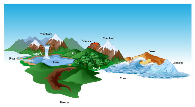
The vector clipart library Geography contains 14 images of geographical features: ocean, forest, river, lake, waterfall, mountains, ravine, volcano, desert, hills, iceberg, trees.
Use the design elements library Geography to draw illustrations with landform images using the ConceptDraw PRO diagramming and vector drawing software.
"A landform in the earth sciences comprises a geomorphological unit, and is largely defined by its surface form and location in the landscape. As part of the terrain a landform is an element of topography. Landform elements also include land such as hills, mountains, plateaus,canyons,valleys, seascape and oceanic waterbody interface features such as bays, peninsulas, seas and so forth, including sub-aqueous terrain features such as mid-ocean ridges, volcanoes,and the great ocean basins." [Landform. Wikipedia]
This landscape illustration example is included in the Nature solution from the Illustration area of ConceptDraw Solution Park.
Geo Map - Africa
Africa has 54 fully recognized sovereign states, 9 territories and two de facto independent states with limited or no recognition. Vector design elements library Africa contains country map contours, geographical maps, cartograms and thematic maps for ConceptDraw PRO diagramming and vector drawing software. To help visualize the business and thematic information connected with geographic areas, locations or customs. All ConceptDraw PRO documents are vector graphic files and are available for reviewing, modifying, and converting to a variety of formats: image, HTML, PDF file, MS PowerPoint Presentation, Adobe Flash, MS Visio (.VDX, .VSDX).- Elements Of Nature River Ocean Mountain Hill Forest Volcano
- Geography - Vector stencils library | Design elements - Geography ...
- Design elements - Geography | Geography - Vector stencils library ...
- Geography - Vector stencils library | Design elements - Geography ...
- Design elements - Geography | Landscape Designs For Volcano ...
- Design elements - Geography | Post and Mail - Design Elements ...
- Design elements - Geography | Nature Drawings - How to Draw ...
- Geographical Features Clipart
- Geography - Vector stencils library | How to Draw a Natural ...
- California relief | California Drawings Volcanoes
- Volcano Infographics
- Geography - Vector stencils library | Design elements - Geography ...
- Geography
- Ski lift in the snow capped mountains | Geography - Vector stencils ...
- Nature | How to Draw a Natural Landscape | How can you illustrate ...
- Beautiful Nature Scene: Drawing | How to Draw a Natural ...
- Nature | How to Draw a Natural Landscape | Geography - Vector ...
- Beauty in nature Illustrations and Clipart | How to Draw a Natural ...
- Design elements - Geography | Geo Map - Asia - Kazakhstan ...
- Design elements - Geography | Rail transport - Design elements ...

