Geo Map of Americas
The Americas are the combined continental landmasses of North America and South America, in the Western Hemisphere. There are 35 sovereign states in the Americas.ConceptDraw is idea to draw the geological maps of America from the pre-designed vector geo map shapes and vector images map of america.
Use Continent Maps solution from the Maps area of ConceptDraw Solution Park to draw thematic maps, geospatial infographics and vector illustrations for your business documents, presentations and websites.
Geo Map — South America Continent
South America includes 12 sovereign states.ConceptDraw DIAGRAM is idea to draw the geological maps of South America continent from the pre-designed vector geo map shapes.
Use Continent Maps solution from the Maps area of ConceptDraw Solution Park to draw thematic maps, geospatial infographics and vector illustrations for your business documents, presentations and websites.
Geo Map - South America - Paraguay
Paraguay, officially the Republic of Paraguay, is a landlocked country in South America, bordered by Argentina to the south and southwest, Brazil to the east and northeast, and Bolivia to the northwest.The vector stencils library Paraguay contains contours for ConceptDraw DIAGRAM diagramming and vector drawing software. This library is contained in the Continent Maps solution from Maps area of ConceptDraw Solution Park.
Geo Map - South America - Brazil
Brazi, officially the Federative Republic of Brazil, is the largest country in both South America and the Latin American region.The vector stencils library Brazil contains contours for ConceptDraw DIAGRAM diagramming and vector drawing software. This library is contained in the Continent Maps solution from Maps area of ConceptDraw Solution Park.
Astronomy
Astronomy solution extends ConceptDraw DIAGRAM software with illustration and sketching software with templates, samples and libraries of a variety of astronomy symbols, including constellations, galaxies, stars, and planet vector shapes; a whole host of cele
Geo Map — South America — Peru
Peru, officially the Republic of Peru, is a country in western South America.The history of Peru goes back to the distant past and its divided into several main stages. Geography of Peru is also diverse - there is a desert, as well as the ocean coast, and of course the mountain ranges.
The Continent Maps solution from Maps area of ConceptDraw Solution Park provides stencil library Peru, which is made up of well-designed vector shapes delivering easy experience in creating diagrams with ConceptDraw DIAGRAM software.
All ConceptDraw DIAGRAM documents are vector graphic files and are available for reviewing, modifying, and converting to a variety of formats: image, HTML, PDF file, MS PowerPoint Presentation, Adobe Flash, MS Visio (.VDX,.VSDX).
Geo Map - South America - Suriname
Suriname, officially known as the Republic of Suriname, is a country on the northeastern Atlantic coast of South America.The vector stencils library Suriname contains contours for ConceptDraw DIAGRAM diagramming and vector drawing software. This library is contained in the Continent Maps solution from Maps area of ConceptDraw Solution Park.
Geo Map — USA — Montana
Montana is a state in the Western United States.The vector stencils library Montana contains contours for ConceptDraw DIAGRAM diagramming and vector drawing software. This library is contained in the Continent Maps solution from Maps area of ConceptDraw Solution Park.
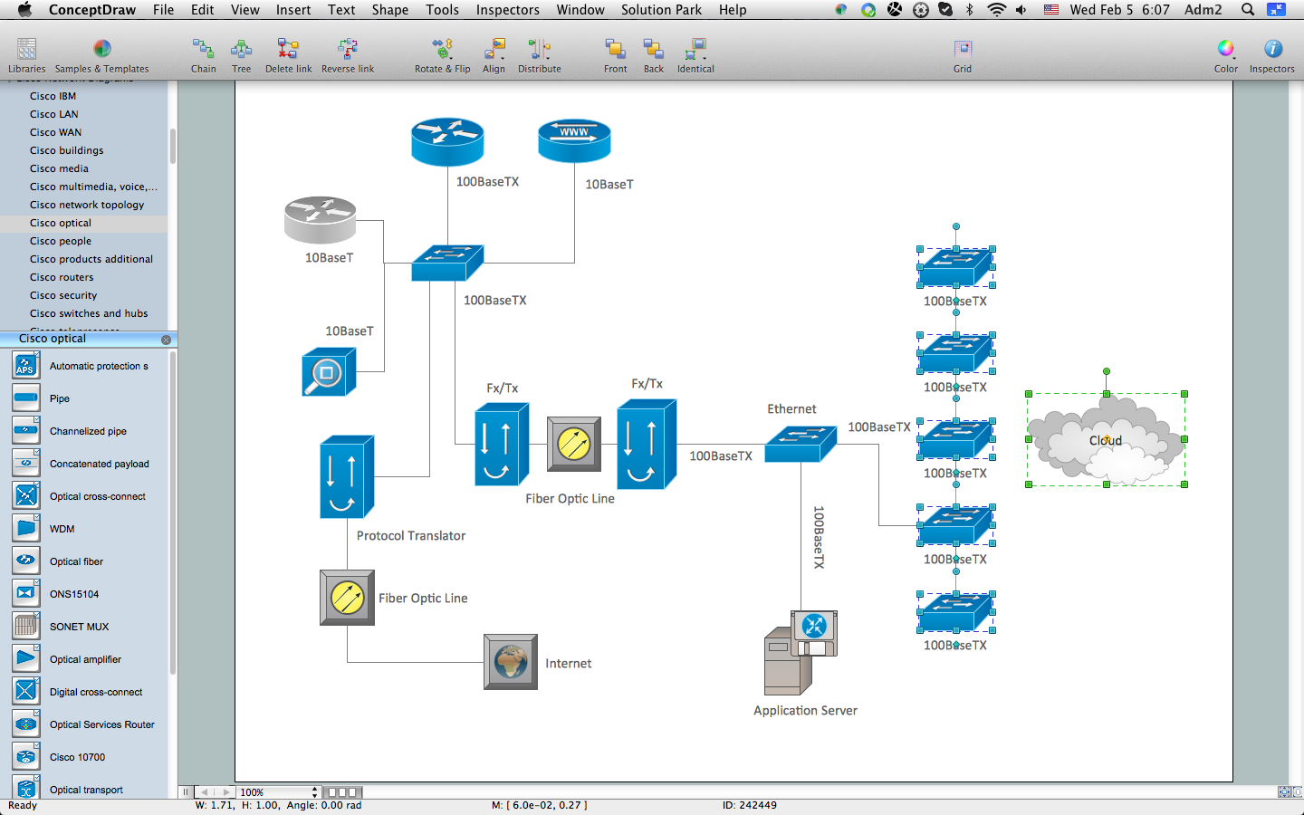
How to Create Cisco Network Diagram
The Cisco Network Diagrams Solution from the Computer and Networks area of ConceptDraw Solution Park helps you to create the Cisco Network Diagrams quick and easy using the ConceptDraw DIAGRAM diagramming and vector drawing software.The Cisco Network Diagrams Solution contains 14 libraries with 450 ready-to-use predesigned vector objects.
Geo Map - USA - California
California is a state located on the West Coast of the United States.The vector stencils library California contains contours for ConceptDraw DIAGRAM diagramming and vector drawing software. This library is contained in the Continent Maps solution from Maps area of ConceptDraw Solution Park.
Geo Map — United States of America Map
United States is a federal republic consisting of 50 states and a federal district.ConceptDraw is idea to draw the geological map of the United States of America from the pre-designed vector geo map shapes.
Each map is scaled, with the option to add further levels of detail - county borders, their names, capitals and major cities can be shown or hidden using the action menu for each state map. ConceptDraw DIAGRAM gives you full control over map size, shading, color fills and alignment.
Use the Continent Maps solution for easy drawing professional looking geological maps, thematic maps, geospatial infographics and vector illustrations for your business documents, presentations and websites.
Geo Map - South America - Mexico
Mexico, officially the United Mexican States, is a federal republic in North America.The vector stencils library Mexico contains contours for ConceptDraw DIAGRAM diagramming and vector drawing software. This library is contained in the Continent Maps solution from Maps area of ConceptDraw Solution Park.
Geo Map — Asia
You can find the map made showing only contour lines of the whole continent of Asia. You can find the one showing the population in each country. The sample provided by the team of CS Odessa which can be found in ConceptDraw STORE in the “Asia” library shows the Central Asia as the core region of the Asian continent which extends from the Caspian Sea in the west to China in the east; from Afghanistan in the south to Russia in the north.There are 116 vector shapes illustrating the Asia countries flags in colours as they are and you can always use some of them or all of them.
Vehicular Network
ConceptDraw DIAGRAM diagramming and vector drawing software offers the Vehicular Networking Solution from the Computer and Networks Area of ConceptDraw Solution Park which makes it the best for designing professional looking vehicular network diagrams.
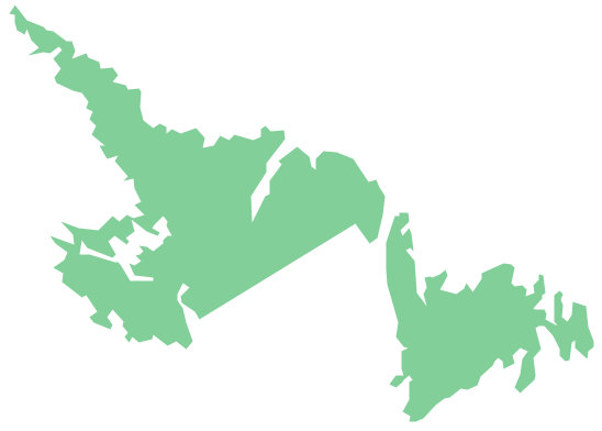
Geo Map - Canada - Newfoundland and Labrador
Newfoundland and Labrador is the easternmost province of Canada.The vector stencils library Newfoundland and Labrador contains contours for ConceptDraw DIAGRAM diagramming and vector drawing software. This library is contained in the Continent Maps solution from Maps area of ConceptDraw Solution Park.
- Mathematical Diagrams | Scientific Symbols Chart | Mathematics ...
- How to Draw Geometric Shapes in ConceptDraw PRO ...
- Mathematics Symbols | Mathematical Diagrams | Mathematics ...
- How to Draw a Pyramid Diagram in ConceptDraw PRO | How to ...
- Mathematical Diagrams | How to Draw Geometric Shapes in ...
- Geometrical Figure With Diagram
- How to Draw Geometric Shapes in ConceptDraw PRO ...
- How to Draw Geometric Shapes in ConceptDraw PRO | Design ...
- Diagram Of Geometric Shapes
- Mathematical Diagrams | Scientific Symbols Chart | How to Draw ...
- Design elements - Solid geometry | Mathematical Diagrams ...
- Geometric Shapes With Diagrams
- Mathematical Diagrams | Basic Flowchart Symbols and Meaning ...
- Tables - Vector stencils library
- Mathematics Symbols | Mathematics | Mathematical Diagrams ...
- Design elements - Solid geometry
- Scientific Symbols Chart | Basic Flowchart Symbols and Meaning ...
- Design elements - Solid geometry | Mathematics Symbols | Scientific ...
- How to Draw Geometric Shapes in ConceptDraw PRO ...
- How to Draw Geometric Shapes in ConceptDraw PRO | Design ...
- ERD | Entity Relationship Diagrams, ERD Software for Mac and Win
- Flowchart | Basic Flowchart Symbols and Meaning
- Flowchart | Flowchart Design - Symbols, Shapes, Stencils and Icons
- Flowchart | Flow Chart Symbols
- Electrical | Electrical Drawing - Wiring and Circuits Schematics
- Flowchart | Common Flowchart Symbols