 Directional Maps
Directional Maps solution extends ConceptDraw DIAGRAM software with templates, samples and libraries of vector stencils for drawing the directional, location, site, transit, road and route maps, plans and schemes.
Directions Maps

The 3D pictorial street maps are used as road maps, route maps, locator maps, transit maps, directional maps, tourist maps with points of interest (POI).
"A point of interest, or POI, is a specific point location that someone may find useful or interesting. ...
Most consumers use the term when referring to hotels, campsites, fuel stations or any other categories used in modern (automotive) navigation systems. ...
The term is widely used in cartography, especially in electronic variants including GIS, and GPS navigation software. In this context the synonym waypoint is common.
A GPS point of interest specifies, at minimum, the latitude and longitude of the POI, assuming a certain map datum. A name or description for the POI is usually included, and other information such as altitude or a telephone number may also be attached. GPS applications typically use icons to represent different categories of POI on a map graphically." [Point of interest. Wikipedia]
The example "3D pictorial street map" was created using the ConceptDraw PRO diagramming and vector drawing software extended with the Directional Maps solution from the Maps area of ConceptDraw Solution Park.
3D pictorial street map

Bubble diagrams in Landscape Design with ConceptDraw DIAGRAM
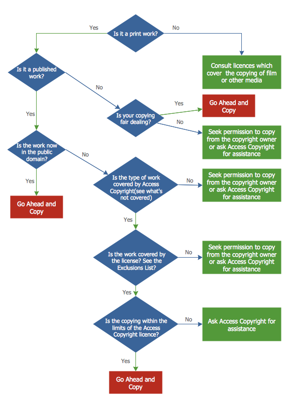
Copying Service Process Flowchart. Flowchart Examples
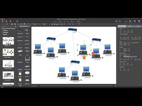
 Vehicular Networking
The Vehicular Networking solution extends the ConceptDraw DIAGRAM software functionality with specialized tools, wide variety of pre-made vector objects, collection of samples and templates in order to help network engineers design vehicular network diagrams for effective network engineering activity, visualize vehicular networks, develop smart transportation systems, design various types of vehicle network management diagrams, regional network diagrams, vehicular communication system diagrams, vehicular ad-hoc networks, vehicular delay-tolerant networks, and other network engineering schemes.
Network Topologies

- 3D pictorial street map | Vehicular Networking | Neighbourhood ...
- Directions Maps | Draw A Street Map Of Your Neighbourhood And ...
- How To Draw Neighborhood Map
- Directions Maps | 3D pictorial street map | Design elements ...
- Neighbourhood Area Network Block Dig
- 2D Directional map - Template
- Directional Maps | 3D Network Diagram Software | Maps and ...
- Directional Map Software
- Directional Maps | 3D pictorial street map | Design elements - 3D ...