Map of Germany — Thuringia State
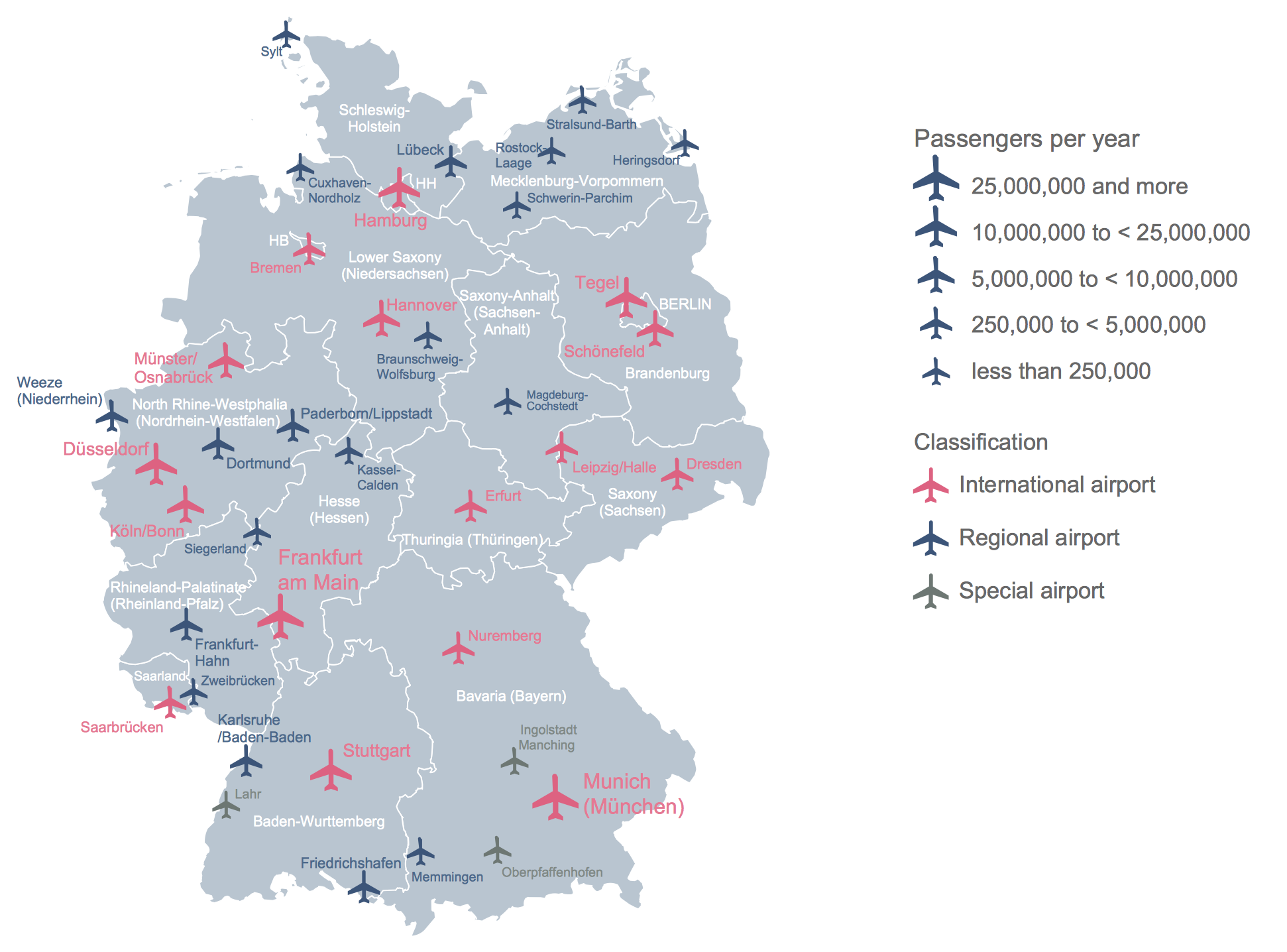
 Germany Map
The Germany Map solution contains collection of samples, templates and scalable vector stencil graphic maps, representing map of Germany and all 16 states of Germany. Use the Germany Map solution from ConceptDraw Solution Park as the base for various them
This example was created on the base of thematic map "Germany: Sugarbeets. Percent of total area by state" from the website of the U.S. Department of Agriculture. [usda.gov/ oce/ weather/ pubs/ Other/ MWCACP/ Graphs/ eur/ grmsugb.gif]
"Sugar beet, cultivated Beta vulgaris, is a plant whose root contains a high concentration of sucrose. It is grown commercially for sugar production.
In 2011, France, the United States, Germany, Russia, and Ukraine were the world's five largest sugar beet producers by mass, whilst by value Turkey takes the place of Ukraine. However, in 2010–2011, North America, Western Europe, and Eastern Europe did not produce enough sugar from sugar beets to meet overall demand for sugar, and were all net importers of sugar. ... In 2009, sugar beets accounted for 20% of the world's sugar production." [Sugar beet. Wikipedia]
The thematic map example "Germany crop areas map - Sugar beets" was designed using the ConceptDraw PRO software extended with the Map of Germany solution from the Maps area of ConceptDraw Solution Park.
Germany thematic map example

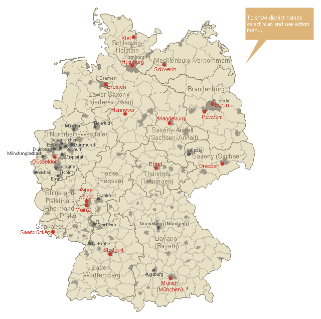
This Germany political map example was created on the base of Wikimedia Commons file: Landkreise, Kreise und kreisfreie Städte in Deutschland 2011-09-04.svg. [commons.wikimedia.org/ wiki/ File:Landkreise,_ Kreise_ und_ kreisfreie_ St%C3%A4dte_ in_ Deutschland_ 2011-09-04.svg]
This file is licensed under the Creative Commons Attribution 3.0 Unported license. [creativecommons.org/ licenses/ by/ 3.0/ deed.en]
"A German district is an administrative subdivision known as Landkreis ("rural district"), except in the states of North Rhine-Westphalia and Schleswig-Holstein where it is known simply as Kreis. Most major cities in Germany are not part of a rural district, but perform district-like functions on their own. In this context, those cities are referred to as Kreisfreie Stadt (literally "district-free town") or Stadtkreis ("urban district").
Rural districts are at an intermediate level of administration between the German states (Länder) and the municipal governments (Gemeinden). They correspond to level 3 administrative units of the Nomenclature of Territorial Units for Statistics (NUTS 3)..." [Districts of Germany. Wikipedia]
The thematic map example "Map of Germany districts" was designed using the ConceptDraw PRO software extended with the Map of Germany solution from the Maps area of ConceptDraw Solution Park.
Political map example
This Germany political map example was created on the base of Wikimedia Commons file: Map Germany Länder-en.svg. [commons.wikimedia.org/ wiki/ File:Map_ Germany_ Länder-en.svg]
This file is licensed under the Creative Commons Attribution-Share Alike 3.0 Unported license. [creativecommons.org/ licenses/ by-sa/ 3.0/ deed.en]
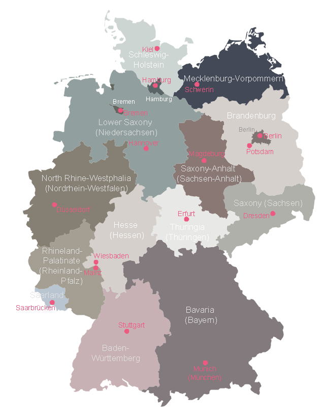
"Germany is a federal republic consisting of sixteen federal states (German: Bundesland, or Land). Since today's Germany was formed from an earlier collection of several states, it has a federal constitution, and the constituent states retain a measure of sovereignty. With an emphasis on geographical conditions, Berlin and Hamburg are frequently called Stadtstaaten (city-states), as is the Free Hanseatic City of Bremen, which in fact includes the cities of Bremen and Bremerhaven. The remaining 13 states are called Flächenländer (literally: area states)." [States of Germany. Wikipedia]
The political map example "Map of German states" was designed using the ConceptDraw PRO software extended with the Map of Germany solution from the Maps area of ConceptDraw Solution Park.
This file is licensed under the Creative Commons Attribution-Share Alike 3.0 Unported license. [creativecommons.org/ licenses/ by-sa/ 3.0/ deed.en]
"Germany is a federal republic consisting of sixteen federal states (German: Bundesland, or Land). Since today's Germany was formed from an earlier collection of several states, it has a federal constitution, and the constituent states retain a measure of sovereignty. With an emphasis on geographical conditions, Berlin and Hamburg are frequently called Stadtstaaten (city-states), as is the Free Hanseatic City of Bremen, which in fact includes the cities of Bremen and Bremerhaven. The remaining 13 states are called Flächenländer (literally: area states)." [States of Germany. Wikipedia]
The political map example "Map of German states" was designed using the ConceptDraw PRO software extended with the Map of Germany solution from the Maps area of ConceptDraw Solution Park.
Germany federal states map example
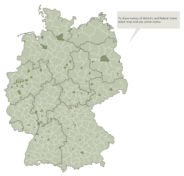
Use this German districts map template to design Germany political or thematic maps with ConceptDraw PRO software.
You can show or hide borders or names of federal states, districts and main cities, or regions by the map selecting and Action menu commands.
The template "Germany districts map" is included in the Map of Germany solution from the Maps area of ConceptDraw Solution Park.
You can show or hide borders or names of federal states, districts and main cities, or regions by the map selecting and Action menu commands.
The template "Germany districts map" is included in the Map of Germany solution from the Maps area of ConceptDraw Solution Park.
Map of German districts
Maps of Germany
Maps of Germany With Cities

HelpDesk
How to Create a Map of Germany

Vector Map of Germany

- Map of Germany — Lower Saxony State | Germany crop areas map ...
- Map of Germany — Schleswig-Holstein State | Germany Map | Map ...
- Germany districts map - Template
- Map of USA States
- Geo Mapping Software Examples - World Map Outline | Germany ...
- Map of Germany — Saarland State | Germany Map | Map of ...
- Germany Map | Map of Germany — Saarland State | Map of ...
- Benefit Corporation legislation - Thematic map | USA Map | USA ...
- How to Create a Map of Germany Using ConceptDraw PRO ...