How to draw Metro Map style infographics? (New York)
How to draw Metro Map style infographics of New York subway. New York Subway has a long history starting on October 27, 1904. Since the opening many agencies have provided schemes of the subway system. At present time are 34 lines in use. This page present New York City subway map construct with Metro Map Solution in Conceptdraw PRO software. This is a one-click tool to add stations to the map. It lets you control the direction in which you create new stations, change lengths, and add text labels and icons. It contains Lines, Stations, and Landmarks objectsGym Floor Plan
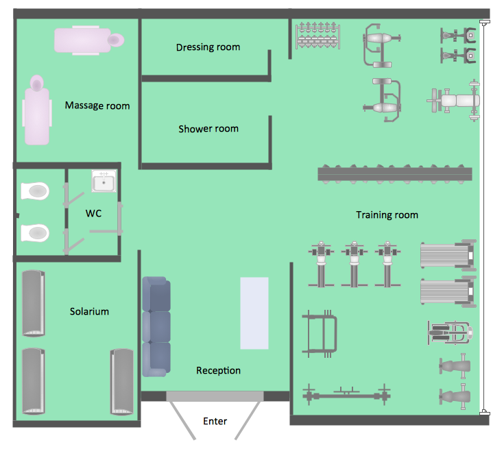
ConceptDraw PRO extended with Gym and Spa Area Plans solution from Building Plans area of ConceptDraw Solution Park is ideal software for quick and simple drawing professional looking Gym Floor Plan.
 Metro Map
Metro Map solution extends ConceptDraw PRO software with templates, samples and library of vector stencils for drawing the metro maps, route maps, bus and other transport schemes, or design tube-style infographics.
 Aerospace and Transport
This solution extends ConceptDraw PRO software with templates, samples and library of vector clipart for drawing the Aerospace and Transport Illustrations. It contains clipart of aerospace objects and transportation vehicles, office buildings and anci
 Metro Map
Metro Map solution extends ConceptDraw PRO software with templates, samples and library of vector stencils for drawing the metro maps, route maps, bus and other transport schemes, or design tube-style infographics.
 Telecommunication Network Diagrams
Telecommunication Network Diagrams solution extends ConceptDraw PRO software with samples, templates and libraries of vector stencils for drawing the diagrams of telecommunication networks.
 Directional Maps
Directional Maps solution extends ConceptDraw PRO software with templates, samples and libraries of vector stencils for drawing the directional, location, site, transit, road and route maps, plans and schemes.
 Android User Interface
The Android User Interface solution allows ConceptDraw PRO act as an Android UI design tool. Libraries and templates contain a variety of Android GUI elements to help users create images based on Android UI design.
The vector stencils library "Landmarks" contains 69 landmark symbols of buildings, waterways, scale and directional indicators for labeling transportation and directional maps, road and route maps, street and transit maps, locator and tourist maps.
The pictograms example "Landmarks - Vector stencils library" was created using the ConceptDraw PRO diagramming and vector drawing software extended with the Directional Maps solution from the Maps area of ConceptDraw Solution Park.
The pictograms example "Landmarks - Vector stencils library" was created using the ConceptDraw PRO diagramming and vector drawing software extended with the Directional Maps solution from the Maps area of ConceptDraw Solution Park.
- How To Create Restaurant Floor Plan in Minutes | Rail transport ...
- Three Possible Design Solution For The New Railway Station
- Gym Floor Plan | Aerospace and Transport | Metro Map | Train ...
- Simple Railway Station Building Floor Plan
- Café Floor Plan Example | Seating Plans | How To Create ...
- Generate Three Drawing Of Layout Of Railway Station Building ...
- Floor Plan In The Railway Station
- Landmarks - Vector stencils library | Floor Plan Of Railway Station ...
- Floor Plan Of The Railway Station Building
- Railway Station Floor Plan
- Railway Station Floor Plan With Coffee Shop Toilets And Office
- Floor Plans For Railway Station Building
- Railway Station Building Floor Plan
- Toilet Symbol Floor Plan
- Floor Plan Of A Raliway Station With Station Building Drawings
- Ezample Of Floor Plan Of The Railaay Station Building
- Examples Of Floor Plans Of Railway Station Buildings
- What The Drawings Of The Layout Of Three Possible Design
- Office floor plan | Ground floor office plan | Plumbing and Piping ...
- Railway Stations Buildings And Floor Plan


