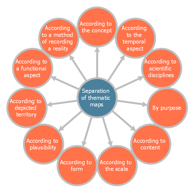
This circle-spoke diagram sample shows the basic division of thematic maps. It was designed on the base of the Wikimedia Commons file: Dělení tematických map.png.
[commons.wikimedia.org/ wiki/ File:D%C4%9Blen%C3%AD_ tematick%C3%BDch_ map.png]
This file is licensed under the Creative Commons Attribution-Share Alike 4.0 International license. [creativecommons.org/ licenses/ by-sa/ 4.0/ deed.en]
"A thematic map is a map that focuses on a specific theme or subject area. This is in contrast to general reference maps, which regularly show the variety of phenomena — geological, geographical, political — together. The contrast between them lies in the fact that thematic maps use the base data, such as coastlines, boundaries and places, only as points of reference for the phenomenon being mapped. General maps portray the base data, such as landforms, lines of transportation, settlements, and political boundaries, for their own sake.
Thematic maps emphasize spatial variation of one or a small number of geographic distributions. These distributions may be physical phenomena such as climate or human characteristics such as population density and health issues." [Thematic map. Wikipedia]
The hub-and-spoke diagram example "Division of thematic maps" was created using the ConceptDraw PRO diagramming and vector drawing software extended with the Circle-Spoke Diagrams solution from the area "What is a Diagram" of ConceptDraw Solution Park.
Circle-spoke diagram
Visualization Spatial Data Using Thematic Maps Combined with Infographics

 UK Map
The Map of UK solution contains collection of professionally designed samples and scalable vector stencil graphics maps, representing the United Kingdom counties, regions and cities. Use the Map of UK solution from ConceptDraw Solution Park as the base fo
Vector Map of Germany

UK Map

Geo Map - Africa - Uganda

Geo Map - Africa

 USA Maps
Use the USA Maps solution to create a map of USA, a US interstate map, printable US maps, US maps with cities and US maps with capitals. Create a complete USA states map.
 Circle-Spoke Diagrams
Examples of subject areas that are well suited to this approach are marketing, business, products promotion, process modeling, market, resource, time, and cost analysis. Circle-Spoke Diagrams are successfully used in presentations, conferences, management documents, magazines, reportages, reviews, reports, TV, and social media.
Geo Map - Europe - Iceland

Geo Map - Europe - Ukraine

Geo Map - Europe

 Australia Map
For graphic artists creating accurate maps of Australia. The Australia Map solution - allows designers to map Australia for their needs, offers a collection of scalable graphics representing the political geography of Australia, split into distinct state
Geo Map - Europe - Moldova

Map of UK — Channel Islands

- Division of thematic maps | Circle-Spoke Diagrams | Visualization ...
- Visualization Spatial Data Using Thematic Maps Combined with ...
- Relations diagram - Health care | Functional Block Diagram | Design ...
- Map of USA with state names | Benefit Corporation legislation ...
- Benefit Corporation legislation - Thematic map | Continent Maps ...
- Languages of South America - Thematic map | The most spoken ...
- Language Learning | SDL — Systems Engineering | Languages of ...
- Australia states time zones - Thematic map | Continent Maps | Geo ...
- Pyramid Diagram | Time, quality, money triangle diagram | Australia ...
- Venn Diagram Examples for Problem Solving. Environmental Social ...
- Concept Maps | Concept Mapping | The Best Choice for Creating ...
- Division of thematic maps
- How to Draw a Map of North America Using ConceptDraw PRO ...
- Map of Continents | Continent Maps | Campus Area Networks (CAN ...
- Design elements - Thematic maps | How to Create a Directional Map ...
- North America Thematic Map
- World Continents Diagram
- How to Draw a Map of North America Using ConceptDraw PRO ...
- Visualization Spatial Data Using Thematic Maps Combined with
- How to Draw a Map of North America Using ConceptDraw PRO ...