"A transit map is a topological map in the form of a schematic diagram used to illustrate the routes and stations within a public transport system - whether this be bus lines, tramways, rapid transit, commuter rail or ferry routes. The main components are color coded lines to indicate each line or service, with named icons to indicate stations or stops. ...
There are a growing number of books, websites and works of art on the subject of urban rail and metro map design and use. There are now hundreds of examples of diagrams in an urban rail or metro map style that are used to represent everything from other transit networks like buses and national rail services to sewerage systems and Derbyshire public houses." [Transit map. Wikipedia]
The transportation map template for the ConceptDraw PRO diagramming and vector drawing software is included in the Spatial Infographics solution from the area "What is Infographics" of ConceptDraw Solution Park.
Transit map

"A transit map is a topological map in the form of a schematic diagram used to illustrate the routes and stations within a public transport system - whether this be bus lines, tramways, rapid transit, commuter rail or ferry routes. The main components are color coded lines to indicate each line or service, with named icons to indicate stations or stops.
Transit maps can be found in the transit vehicles, at the platforms or in printed timetables. Their primary function is to help users to efficiently use the public transport system, including which stations function as interchange between lines. Unlike conventional maps, transit maps are usually not geographically accurate - instead they use straight lines and fixed angles, and often illustrate a fixed distance between stations, compressing those in the outer area of the system and expanding those close to the center." [Transit map. Wikipedia]
This transit map template for the ConceptDraw PRO diagramming and vector drawing software is included in the Metro Map solution from the Maps area of ConceptDraw Solution Park.
www.conceptdraw.com/ solution-park/ maps-metro-map
Transit map

 Metro Map
Metro Map solution extends ConceptDraw DIAGRAM software with templates, samples and library of vector stencils for drawing the metro maps, route maps, bus and other transport schemes, or design tube-style infographics.
The vector stencils library "Transport map" contains 96 signs and pictograms for drawing road and transit maps.
"A transit map is a topological map in the form of a schematic diagram used to illustrate the routes and stations within a public transport system - whether this be bus lines, tramways, rapid transit, commuter rail or ferry routes. The main components are color coded lines to indicate each line or service, with named icons to indicate stations or stops.
Transit maps can be found in the transit vehicles, at the platforms or in printed timetables. Their primary function is to help users to efficiently use the public transport system, including which stations function as interchange between lines. Unlike conventional maps, transit maps are usually not geographically accurate - instead they use straight lines and fixed angles, and often illustrate a fixed distance between stations, compressing those in the outer area of the system and expanding those close to the center." [Transit map. Wikipedia]
The pictograms example "Design elements - Transport map" was created using the ConceptDraw PRO diagramming and vector drawing software extended with the Spatial Infographics solution from the Maps area of ConceptDraw Solution Park.
Transport map pictograms

 AWS Architecture Diagrams
AWS Architecture Diagrams with powerful drawing tools and numerous predesigned Amazon icons and AWS simple icons is the best for creation the AWS Architecture Diagrams, describing the use of Amazon Web Services or Amazon Cloud Services, their application for development and implementation the systems running on the AWS infrastructure. The multifarious samples give you the good understanding of AWS platform, its structure, services, resources and features, wide opportunities, advantages and benefits from their use; solution’s templates are essential and helpful when designing, description and implementing the AWS infrastructure-based systems. Use them in technical documentation, advertising and marketing materials, in specifications, presentation slides, whitepapers, datasheets, posters, etc.
How to draw Metro Map style infographics? (New York)

Types of Map - Overview

How to draw Metro Map style infographics? (Los Angeles)

"There are a growing number of books, websites and works of art on the subject of urban rail and metro map design and use. There are now hundreds of examples of diagrams in an urban rail or metro map style that are used to represent everything from other transit networks like buses and national rail services to sewerage systems and Derbyshire public houses.
One of the most well-known adaptations of an urban rail map was The Great Bear by Simon Patterson. First shown in 1992 nominated for the Turner Prize The Great Bear replaces station names on the London Underground map with those of explorers, saints, film stars, philosophers and comedians. Other artists such as Scott Rosenbaum, and Ralph Gray have also taken the iconic style of the urban rail map and made new artistic creations ranging from the abstract to the solar system. Following the success of these the idea of adapting other urban rail and metro maps has spread so that now almost every major subway or rapid transit system with a map has been doctored with different names, often anagrams of the original station name." [Transit map. Wikipedia]
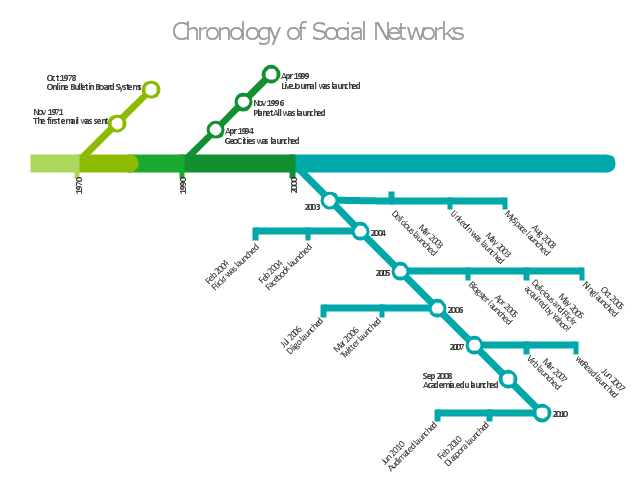
The infographics example "Chronology of social networks" was created using the ConceptDraw PRO diagramming and vector drawing software extended with the Metro Map solution from the Maps area of ConceptDraw Solution Park.
One of the most well-known adaptations of an urban rail map was The Great Bear by Simon Patterson. First shown in 1992 nominated for the Turner Prize The Great Bear replaces station names on the London Underground map with those of explorers, saints, film stars, philosophers and comedians. Other artists such as Scott Rosenbaum, and Ralph Gray have also taken the iconic style of the urban rail map and made new artistic creations ranging from the abstract to the solar system. Following the success of these the idea of adapting other urban rail and metro maps has spread so that now almost every major subway or rapid transit system with a map has been doctored with different names, often anagrams of the original station name." [Transit map. Wikipedia]
The infographics example "Chronology of social networks" was created using the ConceptDraw PRO diagramming and vector drawing software extended with the Metro Map solution from the Maps area of ConceptDraw Solution Park.
Infographics
Using Both Wired and Wireless Connections

- Circuit Diagram For Bus Transportation System
- Metro Map | Transit map template | Transport map - Template ...
- Transit map template | Transport map - Template | Spatial ...
- Transit map template | Transport map - Template | Metro Map ...
- Transit map template | Design elements - Transport map | How to ...
- Transit map template
- Spatial infographics Design Elements: Transport Map | Transit map ...
- Transit map template | Maps | Metro Map | Transit Maps
- Bus network topology diagram | Transmission paths - Vector stencils ...
- Design elements - Transport map | Transit map template | Transport ...