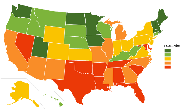
"The United States Peace Index (USPI) is a measurement of American States and cities by their peacefulness. Created by the Institute for Economics and Peace, the creators of the Global Peace Index, it is said to be the first in a series of National sub-divisions by their peacefulness." [United States Peace Index. Wikipedia]
This thematic map example was redesigned from the Wikimedia Commons file: 2011 USPI map.png.
[commons.wikimedia.org/ wiki/ File:2011_ USPI_ map.png]
This file is licensed under the Creative Commons Attribution 3.0 Unported license. [creativecommons.org/ licenses/ by/ 3.0/ deed.en]
The thematic map example "Ranks US states by peacefulness" was created using the ConceptDraw PRO diagramming and vector drawing software extended with the Continent Map solution from the Maps area of ConceptDraw Solution Park.
- Ranks US states by peacefulness | Geo Map - United States of ...
- Ranks US states by peacefulness | United States Peace Index
- Benefit Corporation legislation - Thematic map | Map of USA with ...
- Geo Map - United States of America Map | USA Maps | Map of USA ...
- Ranks US states by peacefulness | Organizational chart - United ...
- Geo Map - America - United States | Map of USA with state names ...
- Geo Map - America - United States
- Geo Map - South America Continent | Geo Map of America | Andean ...
- Geo Map - America - United States | 2012 United States presidential ...
- American Map States
