Geo Map — Europe

Geo Map - Australia

Geo Map - Africa

Vector design elements library Africa contains country map contours, geographical maps, cartograms and thematic maps for ConceptDraw DIAGRAM diagramming and vector drawing software. To help visualize the business and thematic information connected with geographic areas, locations or customs.
All ConceptDraw DIAGRAM documents are vector graphic files and are available for reviewing, modifying, and converting to a variety of formats: image, HTML, PDF file, MS PowerPoint Presentation, Adobe Flash, MS Visio (.VDX,.VSDX).
Vector Map of Germany

Geo Map - Canada

ConceptDraw DIAGRAM is idea to draw the geological maps of Canada from the pre-designed vector geo map shapes.
Export from ConceptDraw DIAGRAM Document to a Graphic File

ConceptDraw DIAGRAM can save your drawings and diagrams in a number of highly useful formats, including graphic files. You can save your drawing as a.PNG,.JPG, or other graphic format file.

 USA Maps
Use the USA Maps solution to create a map of USA, a US interstate map, printable US maps, US maps with cities and US maps with capitals. Create a complete USA states map.
Map of USA States

Geo Map — South America Continent

ConceptDraw DIAGRAM is idea to draw the geological maps of South America continent from the pre-designed vector geo map shapes.
Use Continent Maps solution from the Maps area of ConceptDraw Solution Park to draw thematic maps, geospatial infographics and vector illustrations for your business documents, presentations and websites.
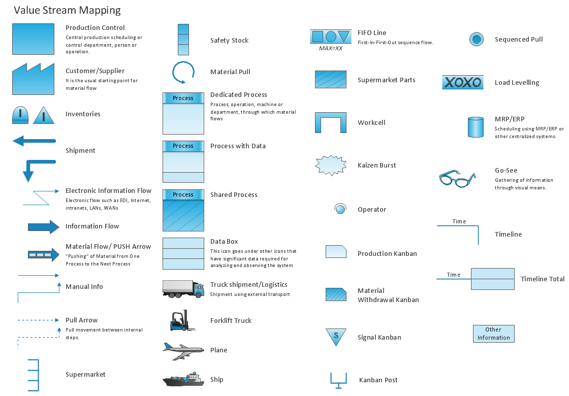
Lean Manufacturing Diagrams
 Germany Map
The Germany Map solution contains collection of samples, templates and scalable vector stencil graphic maps, representing map of Germany and all 16 states of Germany. Use the Germany Map solution from ConceptDraw Solution Park as the base for various them
Geo Map — United States of America Map

ConceptDraw is idea to draw the geological map of the United States of America from the pre-designed vector geo map shapes.
Each map is scaled, with the option to add further levels of detail - county borders, their names, capitals and major cities can be shown or hidden using the action menu for each state map. ConceptDraw DIAGRAM gives you full control over map size, shading, color fills and alignment.
Use the Continent Maps solution for easy drawing professional looking geological maps, thematic maps, geospatial infographics and vector illustrations for your business documents, presentations and websites.
Geo Map — Asia

There are 116 vector shapes illustrating the Asia countries flags in colours as they are and you can always use some of them or all of them.
Map of UK — Channel Islands
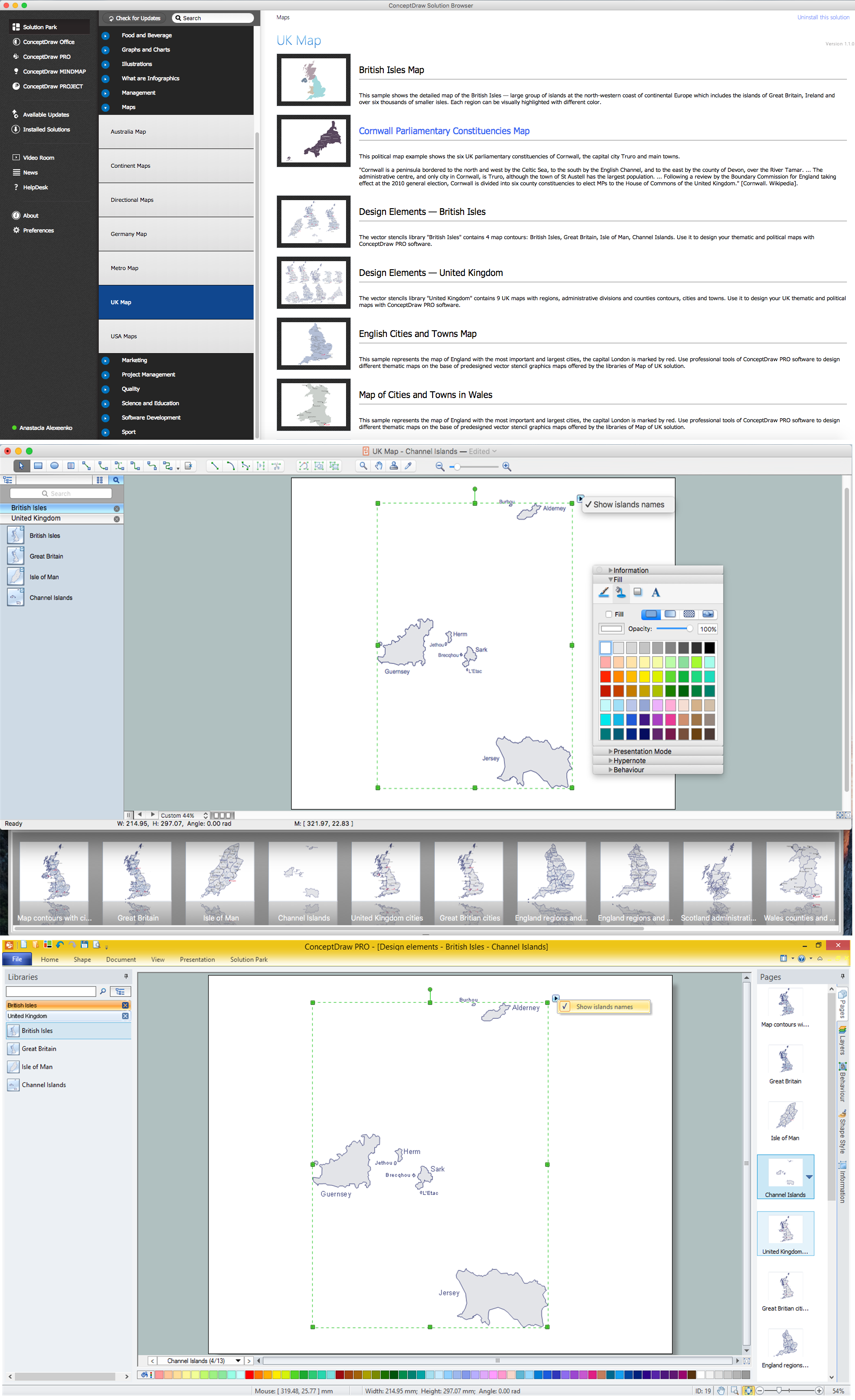
How to design the Map of UK fast and easy? It is incredibly convenient to use special software. ConceptDraw DIAGRAM diagramming and vector drawing software offers the Map of UK Solution from the Maps Area of ConceptDraw Solution Park specially developed to make easier drawing the maps of UK counties, various UK related thematic maps and cartograms on their base.
Geo Map of Americas

ConceptDraw is idea to draw the geological maps of America from the pre-designed vector geo map shapes and vector images map of america.
Use Continent Maps solution from the Maps area of ConceptDraw Solution Park to draw thematic maps, geospatial infographics and vector illustrations for your business documents, presentations and websites.
- Png Images Of Mountains Vector
- Design elements - Transport map | Supermarket Signs Png
- Vicious circle - Crystal diagram | Geo Map - Europe - France ...
- Design elements - Geography | Geo Map - Asia - Kazakhstan ...
- USA Maps | Design elements - Geography | Geo Map - Europe ...
- Oceania Vector Map Png
- Watercraft - Design Elements | Packaging, loading, customs - Vector ...
- Geography - Vector stencils library | Design elements - Geography ...
- Geo Map - Europe | Design elements - Geography | Geography ...
- Design elements - Travel and tourism pictograms | Travel and ...
- Subway Train Map | Design elements - Rail transport | Rail transport ...
- Directional Maps | Map Directions | Sign Making Software | A Png ...
- Design elements - Subway map , Map symbols | Map symbols ...
- Oceania flags - Vector stencils library | Design elements - Oceania ...
- Location Png Vector
- Types of Map - Overview | Road Transport - Design Elements | Maps ...
- Png Indonesia Map Infographic Element
- Infographic Elements Png
- Railway Vector Png
- Rail transport - Vector stencils library | How to draw Metro Map style ...
- ERD | Entity Relationship Diagrams, ERD Software for Mac and Win
- Flowchart | Basic Flowchart Symbols and Meaning
- Flowchart | Flowchart Design - Symbols, Shapes, Stencils and Icons
- Flowchart | Flow Chart Symbols
- Electrical | Electrical Drawing - Wiring and Circuits Schematics
- Flowchart | Common Flowchart Symbols
- Flowchart | Common Flowchart Symbols