Geo Map - South America - Argentina
Argentina, officially the Argentine Republic, is a federal republic located in southeastern South America.The vector stencils library Argentina contains contours for ConceptDraw DIAGRAM diagramming and vector drawing software. This library is contained in the Continent Maps solution from Maps area of ConceptDraw Solution Park.
Geo Map - World
ConceptDraw DIAGRAM is idea to draw the geological maps of World from the pre-designed vector geo map shapes.Continent Maps
Continent Maps solution extends ConceptDraw DIAGRAM software with templates, samples and libraries of vector stencils for drawing the thematic maps of continents, state maps of USA and Australia.
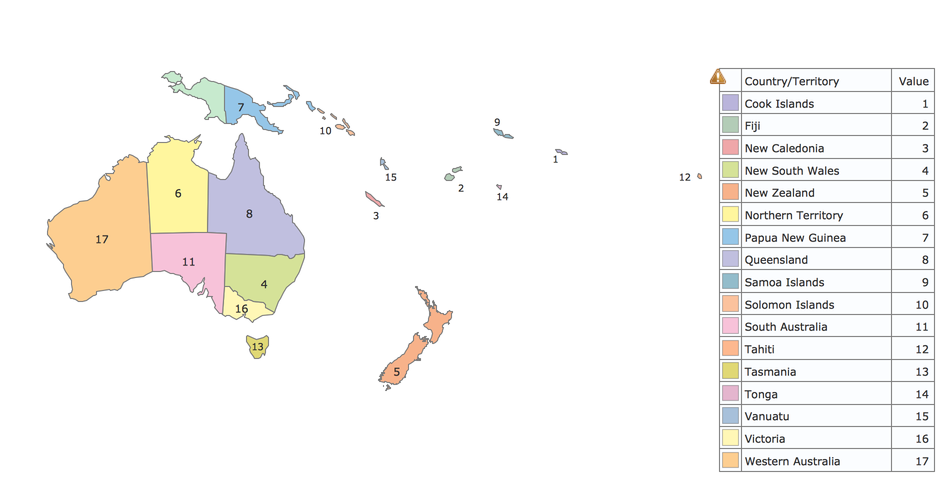
Geo Map - Oceania
The vector stencils library Oceania contains contours for ConceptDraw DIAGRAM diagramming and vector drawing software.Geo Map — United States of America Map
United States is a federal republic consisting of 50 states and a federal district.ConceptDraw is idea to draw the geological map of the United States of America from the pre-designed vector geo map shapes.
Each map is scaled, with the option to add further levels of detail - county borders, their names, capitals and major cities can be shown or hidden using the action menu for each state map. ConceptDraw DIAGRAM gives you full control over map size, shading, color fills and alignment.
Use the Continent Maps solution for easy drawing professional looking geological maps, thematic maps, geospatial infographics and vector illustrations for your business documents, presentations and websites.
Educational Technology Tools
What are the favorite educational technology tools and techniques for teachers? Of course these are pictures, images and education infographics! ConceptDraw DIAGRAM software supplied with Education Infographics Solution from the Business Infographics Area provides powerful drawing tools to help design the education infographics of any complexity.Map of Continents
A continent is one of several very large landmasses on Earth. ConceptDraw DIAGRAM diagramming and vector drawing software offers the unique Continent Maps Solution from the Maps Area which is indispensable for drawing the map of continents of the Earth.- Geo Map - Canada - Prince Edward Island
- Geo Map - Canada
- Canada - Vector stencils library | Geo Map - Canada - Prince ...
- North America - Vector stencils library | Geo Map - South America ...
- North America - Vector stencils library | Geo Map - United States of ...
- Geo Map - South America - Colombia | Geo Map - South America ...
- North America - Vector stencils library | Geo Map of Americas | Geo ...
- Geo Map - South America - Peru | Geo Map - Europe - Czech ...
- Geo Map of Americas
- Political map of Central America | Geo Map - South America ...
- Continent Maps | Basic Flowchart Symbols and Meaning | Process ...
- South America regions - Political map | Canada regions - Political ...
- Geo Map - Asia - Papua New Guinea | Geo Map - Europe - Bulgaria ...
- Geo Map - South America Continent | Languages of South America ...
- Middle East - Political map | Central Asia - Political map | Southwest ...
- South America regions - Political map | East Africa - Political map ...
- South America regions - Political map | Political map of Central ...
- World Continents Map | Continent Maps | South America regions ...
- North America map with capitals - Template | Geo Map - United ...
- North America - Vector stencils library | North America map with ...
- ERD | Entity Relationship Diagrams, ERD Software for Mac and Win
- Flowchart | Basic Flowchart Symbols and Meaning
- Flowchart | Flowchart Design - Symbols, Shapes, Stencils and Icons
- Flowchart | Flow Chart Symbols
- Electrical | Electrical Drawing - Wiring and Circuits Schematics
- Flowchart | Common Flowchart Symbols