Map of Germany

How To use House Electrical Plan Software


Subway infographic design elements - software tools

Building Drawing Software for Design Site Plan


Fire Exit Plan. Building Plan Examples

Map Infographic Maker

Informative and Well-Designed Infographics

How to draw Metro Map style infographics? Moscow, New York, Los Angeles, London

Map Infographic Creator

How To Create Restaurant Floor Plan in Minutes

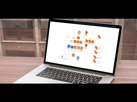
 Network Layout Floor Plans
Network Layout Floor Plans solution extends ConceptDraw DIAGRAM software functionality with powerful tools for quick and efficient documentation the network equipment and displaying its location on the professionally designed Network Layout Floor Plans. Never before creation of Network Layout Floor Plans, Network Communication Plans, Network Topologies Plans and Network Topology Maps was not so easy, convenient and fast as with predesigned templates, samples, examples and comprehensive set of vector design elements included to the Network Layout Floor Plans solution. All listed types of plans will be a good support for the future correct cabling and installation of network equipment.
Sales Process Map

3D Network Diagram Software


Conference Planning Software

Process Flow Maps

Interior Design. Storage and Distribution — Design Elements

The vector stencils library "3D directional maps" contains 40 symbols for creating pictorial maps, street maps, locator maps, transit maps, tourist maps with points of interest (POI), road maps and route maps using the ConceptDraw PRO diagramming and vector drawing software.
"Pictorial maps are a category of maps that are also loosely called illustrated maps, panoramic maps, perspective maps, bird’s-eye view maps and Geopictorial maps amongst others. In contrast to the regular road map, Atlas or topographic cartography, pictorial maps depict a given territory with a more artistic rather than technical style. The cartography can be a sophisticated 3-D perspective landscape or a simple map graphic enlivened with illustrations of buildings, people and animals. They can feature all sorts of varied topics like historical events, legendary figures or local agricultural products and cover anything from an entire continent to a college campus. ...
Pictorial maps usually show an area as if viewed from above at an oblique angle. They are not generally drawn to scale in order to show street patterns, individual buildings, and major landscape features in perspective. While regular maps focus on the accurate rendition of distances, pictorial maps enhance landmarks and often incorporate a complex interplay of different scales into one image in order to give the viewer a more familiar sense of recognition." [Pictorial maps. Wikipedia]
The design elements library "3D directional maps" is included in the Directional Maps solution from the Maps area of ConceptDraw Solution Park.
3D pictorial map symbols

Interior Design. Machines and Equipment — Design Elements

Road Transport - Design Elements

Export from ConceptDraw MINDMAP to PowerPoint® Presentation

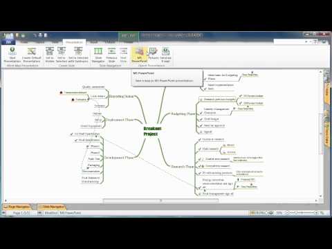
to MS PowerPoint
- Plot Map Design Software Free Download
- House Map For Construction Software
- Spatial infographics Design Elements: Location Map | Superb ...
- Drawing Simple Road Map Software
- Draw Map Commercial Buildings
- Building Drawing Software for Design School Layout | | School Floor ...
- School Floor Plans | Building Drawing Software for Design School ...
- Design elements - Storage and distribution | Spatial infographics ...
- How To Draw Building Plans | Fire Exit Plan. Building Plan ...
- How To use House Electrical Plan Software | Site Plan | Landscape ...
- House Wiring Desine Light Map
- Design elements - Parking and roads | Online Parking Lot Design
- House of Quality Matrix Software | USA Maps | How To use ...
- Directions Map | How to draw Metro Map style infographics ...
- Building Drawing Software for Design Seating Plan | Interior Design ...
- How To use House Electrical Plan Software | Electrical Symbols ...
- Spatial infographics Design Elements: Location Map | Spatial ...
- Process Flowchart | Geo Mapping Software Examples - World Map ...
- Building Drawing Software for Design Office Layout Plan | | Standard ...
- Building Drawing Design Element Site Plan | Vector Map of ...