"Speed skating, or speedskating, is a competitive form of ice skating in which the competitors race each other in traveling a certain distance on skates. Types of speed skating are long track speed skating, short track speed skating, and marathon speed skating. In the Olympic Games, long-track speed skating is usually referred to as just "speed skating", while short-track speed skating is known as "short track". The ISU, the governing body of both ice sports, refers to long track as "speed skating" and short track as "short track skating". ...
The sport originates from pack-style events held in North America and was officially sanctioned in the 1970s, becoming an Olympic sport in 1992. Although this form of speed skating is newer, it is growing faster than long-track speed skating, largely because short track can be done on an ice hockey rink rather than a long-track oval." [Speed skating. Wikipedia]
The vector icon example "Speed skating" represents one of 20 symbols from the Winter sports pictograms library for the ConceptDraw PRO diagramming and vector drawing software.
The design elements library Winter sports pictograms is included in the Winter Sports solution from the Sport area of ConceptDraw Solution Park.
Speed skating
The vector stencils library "Transport map" contains 96 signs and pictograms for drawing road and transit maps.
"A transit map is a topological map in the form of a schematic diagram used to illustrate the routes and stations within a public transport system - whether this be bus lines, tramways, rapid transit, commuter rail or ferry routes. The main components are color coded lines to indicate each line or service, with named icons to indicate stations or stops.
Transit maps can be found in the transit vehicles, at the platforms or in printed timetables. Their primary function is to help users to efficiently use the public transport system, including which stations function as interchange between lines. Unlike conventional maps, transit maps are usually not geographically accurate - instead they use straight lines and fixed angles, and often illustrate a fixed distance between stations, compressing those in the outer area of the system and expanding those close to the center." [Transit map. Wikipedia]
The pictograms example "Design elements - Transport map" was created using the ConceptDraw PRO diagramming and vector drawing software extended with the Spatial Infographics solution from the Maps area of ConceptDraw Solution Park.
Transport map pictograms

The vector stencils library "Recreation signs" contains 28 pictogram symbols of recreation signs for labeling street and directional maps, locator and tourist maps, road and route maps.
"A tourist sign, often referred to as a brown sign, is a traffic sign whose purpose is to direct visitors to tourist destinations, such as historic buildings, tourist regions, caravan or camp sites, picnic areas, sporting facilities and cultural places such as museums. By international convention, brown signs with white lettering and white pictograms are often used for this purpose. ...
Basically these tourist signs have 3 main applications:
(1) Information signs and signposts that point to important tourist destinations or places of interest in the local area, for example within a village or town.
(2) Standard signs that are used to mark routes with special themes, i.e. so-called tourist or holiday routes.
(3) Tourist signs that herald the presence of nearby landscapes, towns and regions, usually on long distance routes such as motorways. They are not used as direction signs." [Tourist sign. Wikipedia]
The pictograms example "Recreation signs - Vector stencils library" was created using the ConceptDraw PRO diagramming and vector drawing software extended with the Directional Maps solution from the Maps area of ConceptDraw Solution Park.
www.conceptdraw.com/ solution-park/ maps-directional
Parking

Amphitheater

Campfire

Cross-country skiing

Volleyball

Supplies/store

Climbing

Handball/racquetball

Boat launch

Downhill skiing

Shower

Fishing

Golf

Skating

Canoe access

Horseback riding

Tennis

Kayaking

Marina

Hiking

Snowboarding

Scuba diving

Swimming

Snowmobile

Restroom

Potable water

Campground

RV

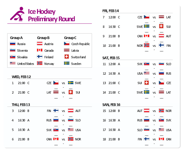
The example "Sochi 2014 Olympics - Men’s hockey tournament schedule" represent Ice Hockey schedule of XXII Olympic Winter Games according to Sochi2014.com website. [sochi2014.com/ en/ ice-hockey-schedule-and-results]
"The 2014 Winter Olympics, officially the XXII Olympic Winter Games, or the 22nd Winter Olympics, are scheduled to take place from 6 to 23 February 2014, in Sochi, Russia, with some events held in the resort town of Krasnaya Polyana. Ninety-eight events in fifteen winter sports will be held. Both the Olympics and 2014 Winter Paralympics are being organized by the Sochi Organizing Committee (SOC). ...
The events of the 2014 Winter Olympics will be held around two clusters of new venues; an Olympic Park was constructed in the Imeretinsky Valley on the coast of the Black Sea, with Fisht Olympic Stadium and the Games' indoor venues located within walking distance, and snow events will be held at Krasnaya Polyana." [2014 Winter Olympics. Wikipedia]
The example "Sochi 2014 Olympics - Men’s hockey tournament schedule" was created using the ConceptDraw PRO diagramming and vector drawing software extended with the Winter Sports solution. The Winter Sports solution from the Sport area of ConceptDraw Solution Park contains the vector stencils library "Winter sports pictograms" and examples of diagrams and infographics.
Men’s hockey tournament schedule
Education Infographics

The vector stencils library "Landmarks" contains 34 signs and pictograms for drawing road and transit maps.
The vector stencils library "Map symbols" contains 10 signs and pictograms for drawing road and transit maps.
"A landmark is a recognizable natural or man-made feature used for navigation, a feature that stands out from its near environment and is often visible from long distances.
In modern use, the term can also be applied to smaller structures or features, that have become local or national symbols." [Landmark. Wikipedia]
The pictograms example "Design elements - Location map" was created using the ConceptDraw PRO diagramming and vector drawing software extended with the Spatial Infographics solution from the Maps area of ConceptDraw Solution Park.
Landmarks and Map symbols

 Astronomy
Astronomy solution extends ConceptDraw PRO software with illustration and sketching software with templates, samples and libraries of a variety of astronomy symbols, including constellations, galaxies, stars, and planet vector shapes; a whole host of cele
 Bubble Diagrams
Bubble diagrams have enjoyed great success in software engineering, architecture, economics, medicine, landscape design, scientific and educational process, for ideas organization during brainstorming, for making business illustrations, presentations, planning, design, and strategy development. They are popular because of their simplicity and their powerful visual communication attributes.
 Wireless Networks
The Wireless Networks Solution extends ConceptDraw PRO software with professional diagramming tools to help network engineers and designers efficiently design and create wireless network diagrams that illustrate wireless networks of any speed and complexity.
 Circle-Spoke Diagrams
Examples of subject areas that are well suited to this approach are marketing, business, products promotion, process modeling, market, resource, time, and cost analysis. Circle-Spoke Diagrams are successfully used in presentations, conferences, management documents, magazines, reportages, reviews, reports, TV, and social media.
 IDEF0 Diagrams
IDEF0 Diagrams visualize system models using the Integration Definition for Function Modeling (IDEF) methodology. Use them for analysis, development and integration of information and software systems, and business process modelling.
 Bar Graphs
The Bar Graphs solution enhances ConceptDraw PRO v10 functionality with templates, numerous professional-looking samples, and a library of vector stencils for drawing different types of Bar Graphs, such as Simple Bar Graph, Double Bar Graph, Divided Bar Graph, Horizontal Bar Graph, Vertical Bar Graph, and Column Bar Chart.
 Pie Charts
Pie Charts are extensively used in statistics and business for explaining data and work results, in mass media for comparison (i.e. to visualize the percentage for the parts of one total), and in many other fields. The Pie Charts solution for ConceptDraw PRO v10 offers powerful drawing tools, varied templates, samples, and a library of vector stencils for simple construction and design of Pie Charts, Donut Chart, and Pie Graph Worksheets.
 Cafe and Restaurant Floor Plans
Restaurants and cafes are popular places for recreation, relaxation, and are the scene for many impressions and memories, so their construction and design requires special attention. Restaurants must to be projected and constructed to be comfortable and e
- Transport pictograms - Vector stencils library | Road transport ...
- Recreation signs - Vector stencils library | Travel and tourism ...
- Sport pictograms . Olympic Games | Winter Sports. Using Winter ...
- Design elements - Transport pictograms | Recreation signs - Vector ...
- Recreation signs - Vector stencils library | Pictogram Village
- Golf Pictogram
- Speed skating - Winter sports pictograms | Cross-country skiing ...
- Distance From Goal Line To Blue Line Hockey
- Transit Pictograms
- Speed skating - Winter sports pictograms | Short track speed skating ...
- Recreation Pictogram Symbols
- Speed skating - Winter sports pictograms | Figure skating - Winter ...
- Design elements - Travel and tourism pictograms
- Ice Hockey Rink Dimensions | Basketball Court Dimensions | Soccer ...
- Sport pictograms . Olympic Games | Design elements - Winter ...
- Road transport - Vector stencils library | Road Transport - Design ...
- Short track speed skating - Winter sports pictograms | Speed skating ...
- Design elements - Shopping pictograms | Landmarks - Vector ...
- Sport pictograms . Olympic Games | Speed skating - Winter sports ...
- Road transport - Vector stencils library | Transport pictograms ...