 Site Plans
The Site Plans solution extends ConceptDraw DIAGRAM with samples, templates and numerous libraries of design elements making it powerful site plan software, ideal for landscape drawing, designing Site Plans, Site Layout Plans, Landscape Design Drawings, Home Site Plans, Hotel Site Plans, Park Site Plans, for developing the residential and commercial landscape design drawings and site plan, parks planning, landscaping territories, lighting trails, for creating drainage facilities, yard layouts, plant maps, outdoor recreational facilities, and irrigation systems plans.
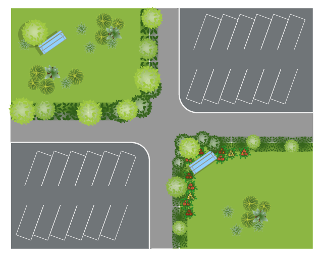
This site plan is the sample of landscape architecture drawing.
"A site plan is an architectural plan, landscape architecture document, and a detailed engineering drawing of proposed improvements to a given lot. A site plan usually shows a building footprint, travelways, parking, drainage facilities, sanitary sewer lines, water lines, trails, lighting, and landscaping and garden elements. ...
Site planning in landscape architecture and architecture refers to the organizational stage of the landscape design process. It involves the organization of land use zoning, access, circulation, privacy, security, shelter, land drainage, and other factors. This is done by arranging the compositional elements of landform, planting, water, buildings and paving and building. Site planning generally begins by assessing a potential site for development through site analysis. Information about slope, soils, hydrology, vegetation, parcel ownership, orientation, etc. are assessed and mapped. By determining areas that are poor for development (such as floodplain or steep slopes) and better for development, the planner or architect can assess optimal location and design a structure that works within this space." [Site plan. Wikipedia]
The landscape design example "Site plan" was created using the ConceptDraw PRO diagramming and vector drawing software extended with the Site Plans solution from the Building Plans area of ConceptDraw Solution Park.
Landscape design
The vector stencils library "Ecology pictograms" contains 20 icons of eco symbols. Use it to draw your ecological infographics. The example "Ecology pictograms - Vector stencils library" was created using the ConceptDraw PRO diagramming and vector drawing software extended with the Pictorial infographics solution from the area "What is infographics" in ConceptDraw Solution Park.
Recycle

Nature

Flower

Butterfly

Earth

Raindrop

Water supply

Eco house

Green home

Electric

Electric lamp

Energy saving bulb

Factory

Power plant

Battery

Bio fuel

Wind turbine

Solar power

Eco

Human footprint

 Sport Field Plans
Sport Field Plans solution extends ConceptDraw DIAGRAM with samples, templates and libraries of ready-made design elements for developing layouts of sport fields, recreation areas, playground layouts plans, and for professional drawing various sport field plans — for football, basketball, volleyball, golf, baseball, tennis, etc. Depict all your playground layout ideas easily and decisively implement the playground layout designs. Use the final colorful, strict and accurate ConceptDraw's playground layouts when designing the building documentation, brochures, booklets, advertising materials, sports editions, sport maps, business plans, on web sites of sport complexes, sport centers, hotels, etc.
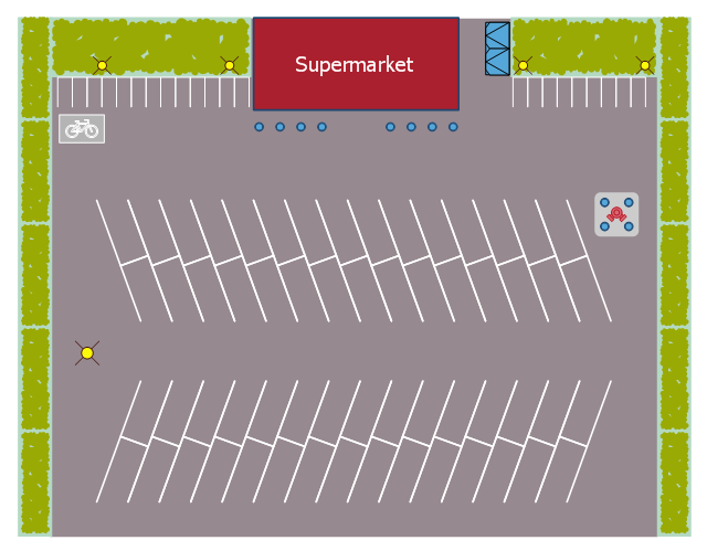
This landscape design sample depicts the supermarket parking site plan.
"Site planning in landscape architecture and architecture refers to the organizational stage of the landscape design process. It involves the organization of land use zoning, access, circulation, privacy, security, shelter, land drainage, and other factors. This is done by arranging the compositional elements of landform, planting, water, buildings and paving in site plans.
Site planning generally begins by assessing a potential site for development through site analysis. Information about slope, soils, hydrology, vegetation, parcel ownership, orientation, etc. are assessed and mapped. By determining areas that are poor for development (such as floodplain or steep slopes) and better for development, the planner or architect can assess optimal location and design a structure that works within this space." [Site planning. Wikipedia]
The site plan example "Supermarket parking" was created using the ConceptDraw PRO diagramming and vector drawing software extended with the Site Plans solution from the Building Plans area of ConceptDraw Solution Park.
Site plan
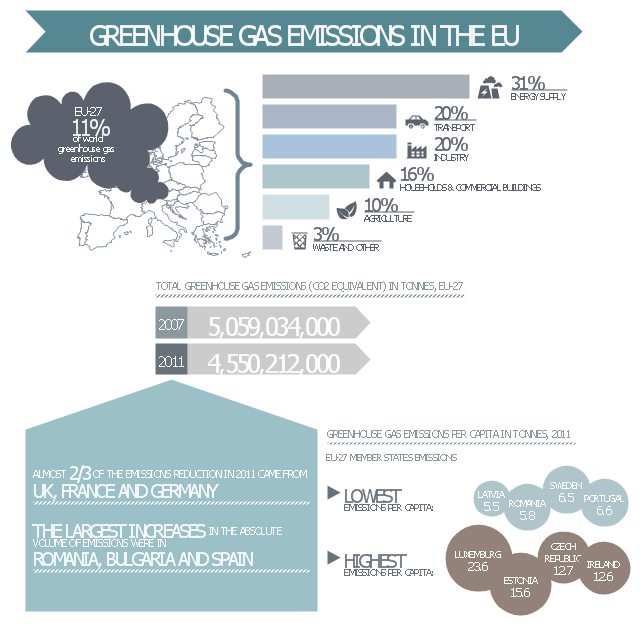
This ecology infographic example was created on the base of the infographics "Greenhouse gas emissions in the EU" from the Debating Europe website. [debatingeurope.eu/ wp-content/ uploads/ 2013/ 06/ TH_ 2_ social.png]
"A greenhouse gas (sometimes abbreviated GHG) is a gas in an atmosphere that absorbs and emits radiation within the thermal infrared range. This process is the fundamental cause of the greenhouse effect. The primary greenhouse gases in the Earth's atmosphere are water vapor, carbon dioxide, methane, nitrous oxide, and ozone. Greenhouse gases greatly affect the temperature of the Earth; without them, Earth's surface would average about 33 °C colder, which is about 59 °F below the present average of 14 °C (57 °F)." [Greenhouse gas. Wikipedia]
The ecology infographic example "EU greenhouse gas emissions" was created using the ConceptDraw PRO diagramming and vector drawing software extended with the Management Infographics solition from the area "Business Infographics" in ConceptDraw Solution Park.
Ecology infographics example
Used Solutions
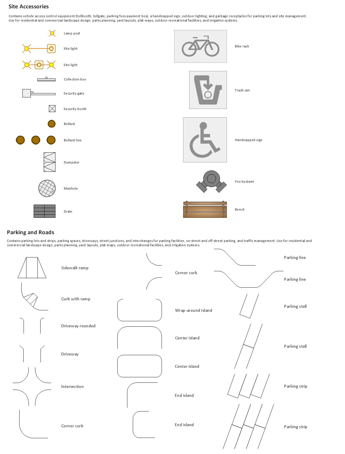
The vector stencils library "Trees and plants" contains 29 symbols of trees, hedges, groundcovers, greenery, and shrubbery. Use these shapes for drawing your site plans, landscape architecture, lawns, gardens, yards, parks planning, groundskeeping, landscape design, and arboretums in the ConceptDraw PRO diagramming and vector drawing software extended with the Site Plans solution from the Building Plans area of ConceptDraw Solution Park.
Conifer tree A

Conifer tree B

Conifer shrub c

Conifer tree D

Deciduous tree A

Deciduous tree B

Deciduous tree C

Deciduous tree D

Broadleaf evergreen tree

Palm tree

Conifer shrub a

Conifer shrub b

Conifer shrub c

Conifer shrub d

Deciduous shrub a

Deciduous shrub b

Deciduous shrub C

Deciduous shrub d

Deciduous shrub e

Broadleaf evergreen shrub

Broadleaf hedge

Conifer hedge

Groundcover

Perennial border

Succulent

Cactus

Ornamental grass

Potted plant 1

Potted plant 2

Building Drawing. Design Element Site Plan

- Gps Logo Png
- Site Plans | Sport Field Plans | Site plan | Vegetation Plan Png
- Playground Furniture Png Top View
- Gps Sattelite Png
- Electric Windmill Logo
- How To use House Electrical Plan Software | Lamp Logo
- Geography - Vector stencils library | Desert Vector Logo
- Wind Mills Png
- Green Eco Vector Png
- Reducing Water For Planting Symbol Png
- Plane Logo
- Solar Garden Pictogram
- Flower Plan Png
- Wind Arrows Png
- Deserts Logo Vector
- Wind Turbines Png
- Buildings Logo Png
- Battery Clipart Png
- Architectural Wind Arrow Png