Map Directions
Directions Maps

 Directional Maps
Directional Maps solution extends ConceptDraw DIAGRAM software with templates, samples and libraries of vector stencils for drawing the directional, location, site, transit, road and route maps, plans and schemes.
Use this template for creating the 3D pictorial road maps, directional maps, location plans, site plans, transit maps, route maps.
"Road maps can ... vary in complexity, from a simple schematic map used to show how to get to a single specific destination (such as a business), to a complex electronic map, which may layer together many different types of maps and information" [Road map. Wikipedia]
This template for the ConceptDraw PRO diagramming and vector drawing software is included in the Directional Maps solution from the Maps area of ConceptDraw Solution Park.
3D pictorial road map template
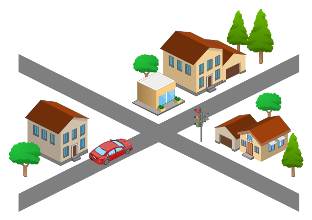
The vector stencils library "3D directional maps" contains 40 symbols for creating pictorial maps, street maps, locator maps, transit maps, tourist maps with points of interest (POI), road maps and route maps using the ConceptDraw PRO diagramming and vector drawing software.
"Pictorial maps are a category of maps that are also loosely called illustrated maps, panoramic maps, perspective maps, bird’s-eye view maps and Geopictorial maps amongst others. In contrast to the regular road map, Atlas or topographic cartography, pictorial maps depict a given territory with a more artistic rather than technical style. The cartography can be a sophisticated 3-D perspective landscape or a simple map graphic enlivened with illustrations of buildings, people and animals. They can feature all sorts of varied topics like historical events, legendary figures or local agricultural products and cover anything from an entire continent to a college campus. ...
Pictorial maps usually show an area as if viewed from above at an oblique angle. They are not generally drawn to scale in order to show street patterns, individual buildings, and major landscape features in perspective. While regular maps focus on the accurate rendition of distances, pictorial maps enhance landmarks and often incorporate a complex interplay of different scales into one image in order to give the viewer a more familiar sense of recognition." [Pictorial maps. Wikipedia]
The design elements library "3D directional maps" is included in the Directional Maps solution from the Maps area of ConceptDraw Solution Park.
3D pictorial map symbols

Excellent Examples of Infographic Maps
How tо Represent Information Graphically
"Road maps come in many shapes, sizes and scales. Small, single-page maps may be used to give an overview of a region's major routes and features. ...
Highway maps generally give an overview of major routes within a medium to large region ranging from a few dozen to a few thousand miles or kilometers.
Street maps usually cover an area of a few miles or kilometers (at most) within a single city or extended metropolitan area. City maps are generally a specialized form of street map." [Road map. Wikipedia]
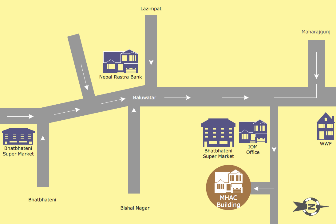
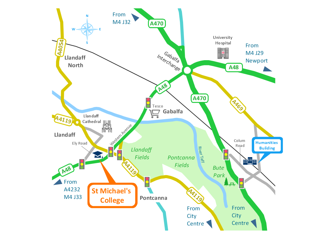
This 3D pictorial road map example was created using the ConceptDraw PRO diagramming and vector drawing software extended with the Directional Maps solution from the Maps area of ConceptDraw Solution Park.
Highway maps generally give an overview of major routes within a medium to large region ranging from a few dozen to a few thousand miles or kilometers.
Street maps usually cover an area of a few miles or kilometers (at most) within a single city or extended metropolitan area. City maps are generally a specialized form of street map." [Road map. Wikipedia]
This 3D pictorial road map example was created using the ConceptDraw PRO diagramming and vector drawing software extended with the Directional Maps solution from the Maps area of ConceptDraw Solution Park.
3D Directional map

Business diagrams & Org Charts with ConceptDraw DIAGRAM
 Funnel Diagrams
Funnel Diagrams solution including wide range of funnel diagram samples, sales funnel examples, and vector design elements, makes the ConceptDraw DIAGRAM ideal for funnel management and creation the Funnel Diagrams of different types and designs, AIDA Model, AIDAS, ACCA Dagmar, Rossiter-Percy Model, Sales funnel, Marketing funnel, Search funnel, Brand funnel, Purchase funnel, Lead funnel, Conversion funnel, Business funnel, etc. You are free to choose to place your funnel object horizontally or vertically, you can use the objects with desired quantity of sales funnel stages, as well as to modify their size, color filling, and other parameters to make exceptionally looking Funnel diagrams fully responding to your desires.
- Road Map
- Drawing Simple Road Map Software
- Directional Maps | Maps Driving Directions | Map Directions ...
- How To Create A Directional Roadmap
- Directional Maps | How to Create a Directional Map | 2D Directional ...
- Site Map Template
- Road Maps Location
- Navigation Road Map Clipart
- Education Package | Directional Maps | Road transport - Vector ...
- Road Map Drawing