Maps Driving Directions
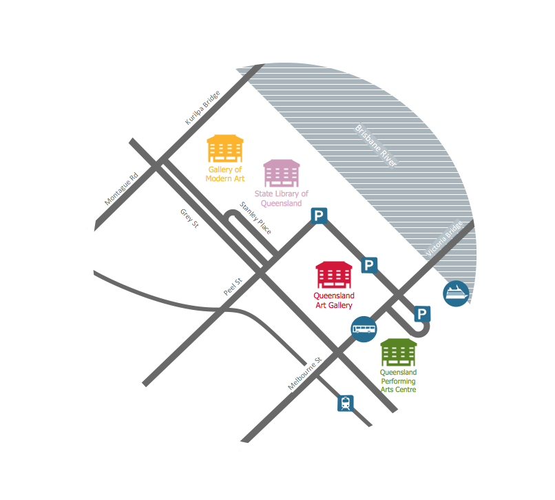
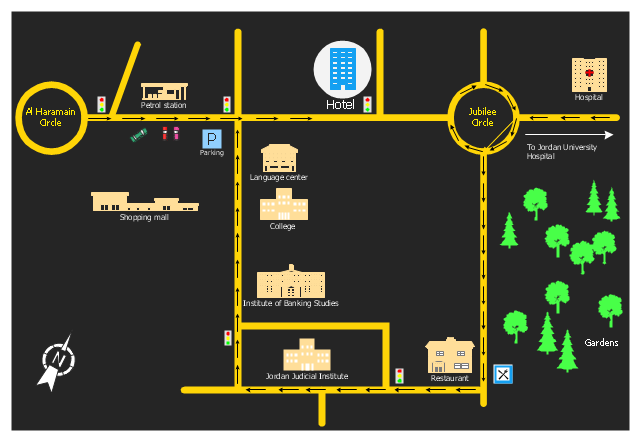
You need visually represent the Maps Driving Directions? Now it's incredibly easy to do this in ConceptDraw PRO diagramming and vector drawing software which was supplied with unique Directional Maps Solution from the Maps Area."A locator map, sometimes referred to simply as a locator, is typically a simple map used in cartography to show the location of a particular geographic area within its larger and presumably more familiar context. Depending on the needs of the cartographer, this type of map can be used on its own or as an inset or addition to a larger map. ...
Direct marketing.
The widespread distribution of sophisticated Geographic Information System (GIS) mapping techniques has allowed the development of large-scale customized locator maps that can be tailored to individual consumers in direct marketing campaigns. This sophistication allows a variety of customized locator maps to be produced in a relatively short period of time. Major types of direct marketing locator maps are:
Single Location: A single business location is shown with major street and road connections. While this type of map can be efficiently constructed using GIS with existing street databases and customized map templates, special software is not required because the map does not change for each direct mailing." [Locator map. Wikipedia]
This example was created using the ConceptDraw PRO diagramming and vector drawing software extended with the Directional Maps solution from the Maps area of ConceptDraw Solution Park.
This location map sample was created on the base on the map "Location of the Migration Health Assessment Center (MHAC)" from the website of the U.S. Embassy in Nepal. "Applicants for U.S. immigrant visas and transportation letters are required to have medical examinations performed by IOM (International Organization for Migration) Embassy panel physicians. ... Health assessments for the immigrants to the US are conducted by the International Organization for Migration (IOM) at the Migration Health Assessment Center."
[nepal.usembassy.gov/ visas/ immigrant-visas/ medical-exams.html]
The location map example "Location of the Migration Health Assessment Center (MHAC)" was created using the ConceptDraw PRO diagramming and vector drawing software extended with the Directional Maps solution from the Maps area of ConceptDraw Solution Park.
The vector stencils library "Recreation signs" contains 28 pictogram symbols of recreation signs for labeling street and directional maps, locator and tourist maps, road and route maps.
"A tourist sign, often referred to as a brown sign, is a traffic sign whose purpose is to direct visitors to tourist destinations, such as historic buildings, tourist regions, caravan or camp sites, picnic areas, sporting facilities and cultural places such as museums. By international convention, brown signs with white lettering and white pictograms are often used for this purpose. ...
Basically these tourist signs have 3 main applications:
(1) Information signs and signposts that point to important tourist destinations or places of interest in the local area, for example within a village or town.
(2) Standard signs that are used to mark routes with special themes, i.e. so-called tourist or holiday routes.
(3) Tourist signs that herald the presence of nearby landscapes, towns and regions, usually on long distance routes such as motorways. They are not used as direction signs." [Tourist sign. Wikipedia]
The pictograms example "Recreation signs - Vector stencils library" was created using the ConceptDraw PRO diagramming and vector drawing software extended with the Directional Maps solution from the Maps area of ConceptDraw Solution Park.
www.conceptdraw.com/ solution-park/ maps-directional
The vector stencils library "Landmarks" contains 69 landmark symbols of buildings, waterways, scale and directional indicators for labeling transportation and directional maps, road and route maps, street and transit maps, locator and tourist maps.
The pictograms example "Landmarks - Vector stencils library" was created using the ConceptDraw PRO diagramming and vector drawing software extended with the Directional Maps solution from the Maps area of ConceptDraw Solution Park.
The pictograms example "Landmarks - Vector stencils library" was created using the ConceptDraw PRO diagramming and vector drawing software extended with the Directional Maps solution from the Maps area of ConceptDraw Solution Park.
The vector stencils library "Landmarks" contains 34 signs and pictograms for drawing road and transit maps.
The vector stencils library "Map symbols" contains 10 signs and pictograms for drawing road and transit maps.
"A landmark is a recognizable natural or man-made feature used for navigation, a feature that stands out from its near environment and is often visible from long distances.
In modern use, the term can also be applied to smaller structures or features, that have become local or national symbols." [Landmark. Wikipedia]
The pictograms example "Design elements - Location map" was created using the ConceptDraw PRO diagramming and vector drawing software extended with the Spatial Infographics solution from the Maps area of ConceptDraw Solution Park.
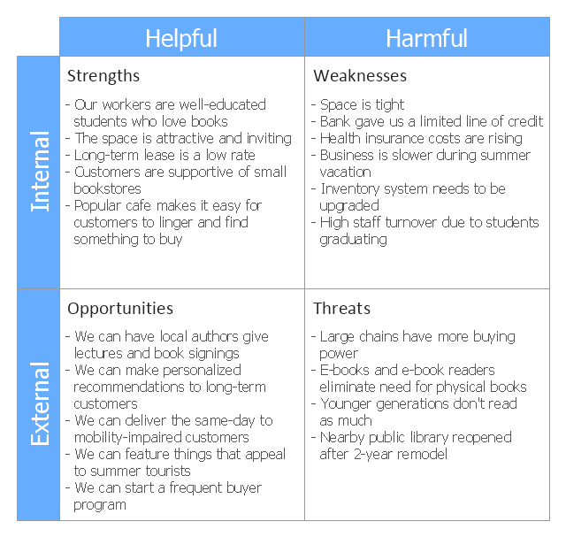
This SWOT matrix diagram example was created on the base of article "An Easy Way To Jumpstart Your Strategic Plan: SWOT" by Leslie Wolf from the website of the California Digital Library, the University of California. "Strategic planning doesn’t have to be a daunting and lengthy process. The goal is really a simple one: to help you understand your world and build a road map to guide your efforts. ...
This analysis tool can help you focus your attention on the specific success factors that are right for your team.
The tool is called a SWOT analysis. SWOT stands for Strengths and Weaknesses, Opportunities and Threats. Here’s what it means:
(1) Strengths are those positive internal attributes that strengthen your business or team. You can develop plans to capitalize on those strengths.
(2) Weaknesses are those negative internal attributes that are working against your success. You can shore up those weaknesses so they don’t stop your success.
(3) Opportunities are those external conditions that can have a positive effect on your goals. These opportunities can point you in the right direction.
(4) Threats are those external conditions that can have a negative effect on your goals. These threats will affect you less if you can identify and minimize them. ...
We thought it would be helpful to show you a sample SWOT analysis for a business you can easily visualize: a small independent bookstore in a university town. The store owner brought the team together to think about how the bookstore could survive during the continuing financial downturn. After an hour of brainstorming, this is the SWOT analysis they developed." [cdlib.org/ cdlinfo/ 2010/ 09/ 29/ an-easy-way-to-jumpstart-your-strategic-plan-swot/ ]
The matrix diagram example "SWOT analysis for a small independent bookstore" was created using the ConceptDraw PRO diagramming and vector drawing software extended with the SWOT Analysis solution from the Management area of ConceptDraw Solution Park.
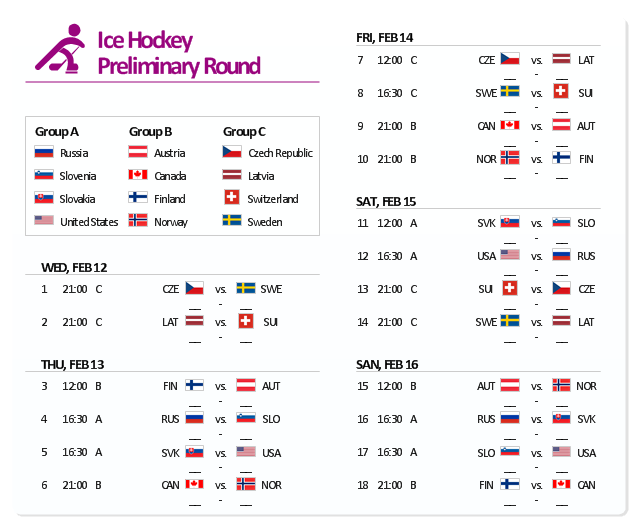
The example "Sochi 2014 Olympics - Men’s hockey tournament schedule" represent Ice Hockey schedule of XXII Olympic Winter Games according to Sochi2014.com website. [sochi2014.com/ en/ ice-hockey-schedule-and-results]
"The 2014 Winter Olympics, officially the XXII Olympic Winter Games, or the 22nd Winter Olympics, are scheduled to take place from 6 to 23 February 2014, in Sochi, Russia, with some events held in the resort town of Krasnaya Polyana. Ninety-eight events in fifteen winter sports will be held. Both the Olympics and 2014 Winter Paralympics are being organized by the Sochi Organizing Committee (SOC). ...
The events of the 2014 Winter Olympics will be held around two clusters of new venues; an Olympic Park was constructed in the Imeretinsky Valley on the coast of the Black Sea, with Fisht Olympic Stadium and the Games' indoor venues located within walking distance, and snow events will be held at Krasnaya Polyana." [2014 Winter Olympics. Wikipedia]
The example "Sochi 2014 Olympics - Men’s hockey tournament schedule" was created using the ConceptDraw PRO diagramming and vector drawing software extended with the Winter Sports solution. The Winter Sports solution from the Sport area of ConceptDraw Solution Park contains the vector stencils library "Winter sports pictograms" and examples of diagrams and infographics.
- Town Map Template
- Example Of Vicinity Map Of The House Wityh Landmark
- Site layout plan | Sign Making Software | Map Directions | Software ...
- Directional Maps | How to Create a Directional Map Using ...
- Geo Map - USA - Illinois | Geo Map - Canada - Manitoba | Geo Map ...
- What Is The Symbol For A Town Hall On A Map
- Superb Examples of Infographic Maps | The 100th Tour de France ...
- Example Of Railway Station Symbols In Maps
- 2D Directional map - Template | Landmarks - Vector stencils library ...
- Hotel locator map | Rolla USGS Center locator map | Maps | Locator ...
- Brilliant Examples of Infographics Map , Transport, Road | Spatial ...
- Directional Map Drawing Software
- Map symbols - Vector stencils library | Recreation signs - Vector ...
- Design elements - Location map | Landmarks - Vector stencils ...
- Landmarks - Vector stencils library | Hotel locator map | Landmarks ...
- Design elements - Location map | Landmarks - Vector stencils ...
- Design elements - Location map
- Road Map Suburbs And Houses Drawing
- Design elements - 3D directional maps | Landmarks - Vector stencils ...
- Map symbols - Vector stencils library | Design elements - Location ...
.png--diagram-flowchart-example.png)


